Upper Sonoran desert on fans, terraces and weakly consolidated pediments with limy soils
This large EU — over 187 square miles — is 90% flat or gently rolling, with slopes less than 18%. It skirts the Catalina and Rincon Mountains in two broad bands. On the west side it runs the Catalina’s Pusch Ridge to the Rincon Valley, taking in mostly private lands with homes. On the east side it is rangeland that stretches from San Manual to Cascabel. Elevations range from 720 m (2340 ft) to 1270 m (4130 ft).
The vegetation is dominated by a mix of creosote, palo verde, and whitethorn, ranging from 1 to 3 meters tall, and providing 5-14% cover. The creosote dominates on ridgelines characterized by obvious accumulations of caliche. Palo verde prefers the slopes that make up about 10% of the EU, where it is joined by saguaro and brittlebush. A mix of creosote and mesquite dominate the old flood terraces bordering large washes like the Rillito, Pantano, and Rincon Creek. Small shrubs give another 5-9% cover. Grasses are sparse, typically less than 5% cover. Buffel grass can be found in the western half of the EU, on disturbed lands that are generally private; its extent is unknown. Buffel grass was not observed on the eastern half of this EU.
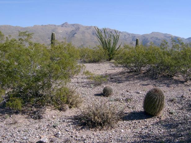
Photo Point 1, NE of intersection of Catalina Highway and Houghton Road, 2700 feet, March 2008. Creosote is the dominant on flats, with 5-9% cover, while foothills palo verde is dominant on slopes.
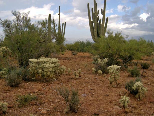
Photo Point 180, two miles south of San Manual, 3000 feet, October, 2008. Foothills palo verde and whitethorn share dominance, each giving 10-14% cover. Chain-fruit cholla adds another 5-9% cover, and fairyduster another 1-4%. Grasses are sparse, with less than 1% cover. Creosote is uncommon.
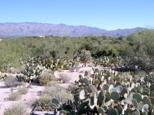
Photo Point 34, looking NNE to the Catalinas, 2900 feet, September, 2007. This site is less than a mile from the cactus forests of Saguaro National Park, yet saguaro is uncommon. The small shrubs Zinnia and paperflower, along with prickly pear, dominate the foreground, with whitethorn (2.5m) and foothill paloverde (3 m) in the background. The prickly pear, whitethorn, and palo verde combine for 25-40% cover. Near the photo station, creosote and mesquite are notably lacking, yet both are common within the same EU approaching the floodplain of the Tanque Verde Wash.
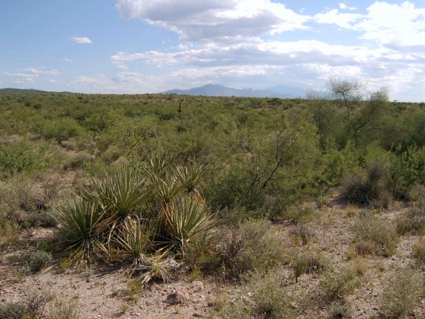
Photo Point 45, 3300 feet, September 2007. Near the intersection of Old Spanish Trail and Camino Loma Alta, about seven miles SE of Saguaro NP headquarters. In the foreground are banana yucca, with the small shrubs Zinnia (0.3m) and mariola (0.5m), along with whitethorn and foothill paloverde (1.5 m and 3 m). These trees and shrubs combine for 10-14% cover. Also common, but with only 1-4% cover, are small shrubs like Croton, Ayenia, and Mendora. The only common bunchgrass is fluffgrass, with 1-4% cover. Saguaros are rare. The creosote bush is uncommon locally, but it becomes the dominant species on what appears to be an old flood terraces near Rincon Creek and Pantano Wash.
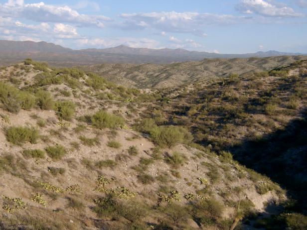
Photo Point 128, in the hills near Cascabel, looking SE over the San Pedro River valley, 3500 feet, September, 2008. Foothill palo verde (2 m) are the easy dominant on south-facing slopes, with 10-14% cover; whitethorn (5-9%), prickly pear (1-4%) and brittlebush (1-4%) are common associates. North-facing slopes are dominated by whitethorn (10-14%), with associated prickly pear (5-9%) and Zinnia (1-4%). Grasses, mainly bush muhly and fluff grass, are sparse (1-4% combined).
Desired Conditions
Desired conditions are adapted from Desert, mid-scale desired condition statements in March 2010 Coronado National Forest planning documents.
On moderately steep hillsides and fan piedmont where alkaline soils are formed in alluvium from mixed parent materials, the predominant species are foothill paloverde, saguaro, prickly pear, cholla, barrel cactus, ocotillo, false mesquite, triangleleaf bursage, bush muhly, slender grama, curly mesquite, spidergrass, tangelhead, purple threeawn, janusia, ayenia and globe mallow. Annual forbs and grasses, an important part of this plant community, fluctuate with precipitation from nearly nothing in dry years to several hundred pounds per acre in wet years. Plant basal cover ranges from 1 to 3 percent, and cover by plant litter ranges from 10 to 75 percent. Canopy cover ranges from 1 to 20 percent for grasses, 1 to 15 percent for forbs, and 5 to 20 percent for shrubs and succulents. Tree canopy cover is 1 to 10 percent.
On moderately steep hillsides and fan piedmont where non-alkaline soils are formed in alluvium from mixed parent materials, the predominant species are foothill paloverde, saguaro, prickly pear, cholla, ocotillo, whitethorn acacia, creosote bush, false mesquite, range ratany, desert zinnia, bush muhly, black grama, slim tridens, fluff grass, janusia, desert senna, and twinberry. Annual forbs and grasses, an important part of this plant community, fluctuate with precipitation from nearly nothing in dry years to several hundred pounds per acre in wet years. Plant basal cover ranges from 1 to 3 percent, and cover by plant litter ranges from 5 to 45 percent. Canopy cover ranges from 1 to 10 percent for grasses, 1 to 10 percent for forbs, and 5 to 20 percent for shrubs and succulents. Tree canopy cover is 1 to 10 percent.
On nearly level floodplains, low stream terraces and canyon bottoms where soils are formed in recent alluvium from mixed parent materials, the predominant species are foothill and blue paloverde, mesquite, catclaw acacia, desert willow, desert hackberry, wolfberry, big bursage, burrobrush, desert honeysuckle, bush muhly, sand and spike dropseed, sideoats grama, tanglehead, spidergrass, and mesa threeawn. Annual forbs and grasses fluctuate with precipitation from nearly nothing in dry years to several hundred pounds per acre in wet years. Plant basal cover ranges from 2 to 5 percent, and cover by plant litter ranges from 5 to 45 percent. Canopy cover ranges from 10 to 20 percent for grasses, 1 to 15 percent for forbs, and 5 to 15 percent for shrubs and succulents. Tree canopy cover is 10 to 15 percent.
Historic Mean Fire Return Interval (Schussman et al. 2006 literature review)
> 250 years for warm desert communities
Primary treatment options (estimated representative project size range):
- Mechanical treatments for fuel reduction and to maintain openings (up to 2,500 acres per project)
- Herbicide treatment for exotics and shrub management to maintain openings and reduce fire spread (up to 1,000 acres per project)
Supplemental treatment option (estimated representative project size range):
- Thinning around developments for safety-related fuel reduction (up to 500 acres per project)
Other Vegetation Classifications:
Areas (polygons) mapped within this EU