Moderate gradient river channel and terraces
Only a few stretches of this EU have perennial water, such as Cienega Creek and the Narrows of the San Pedro River. More typical of the EU is a watercourse 6 to 60 meters wide that flows freely but briefly after seasonal rains, and is scoured by seasonal floods. The larger watercourses, with braided channels, support 2 m tall wands of burro brush, Hymenoclea monogyra (see Photo Point 66, below) while smaller watercourses are often stripped of vegetation. Steep watercourses, even those with water like Bear Canyon and Alder Canyon in the Catalinas, are not part of this EU.
Only 25% of the EU is watercourse; the remainder is usually parallel bands of riparian vegetation, broad flood terraces, and occasional steeper banks. The riparian vegetation is highly variable, from a corridor of 15 m tall cottonwood and willow (see PP 62, below), to 1 m tall tamarisk. The terraces, in contrast, are consistently home to mesquite averaging 5 m, often in bosques with 40-59% cover. The remaining space between the mesquite is usually filled with large summer and spring annuals (up to 1.5 m) such as amaranth, cocklebur, the bursage Ambrosia conferitflora, and the sunflower Verbesinia enceliodes. Bermuda and Johnson grass is also common.
This EU includes Rincon Creek and, in Happy Valley, short stretches of Turkey Creek, Miller Creek, and Paige Creek. These are small watercourses, and included in this EU not for their streamflow (strictly seasonal) but primarily their broad flood terraces with very large sycamore (20 m) and Emory oak (15 m) with 25-39% cover combined (PP 136, below).
This EU includes the San Pedro, Cienega, Canada del Oro, Rillito, Sabino, Aqua Caliente, Aqua Verde, Tanque Verde, Davidson and Pantano. Any habitat that offers shade is both attractive to desert dwellers and highly disturbed by the same. The most common affliction is bosques cleared for home development or, along the San Pedro, agriculture.
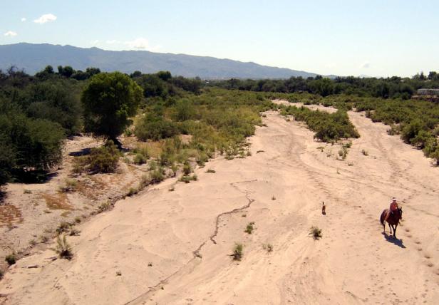
Photo Point 66, Tanque Verde Wash, looking SE from the bridge on Tanque Verde Road, 2500 feet, September 2008. The vegetation in the watercourse is mostly burro brush, Hymenoclea monogyra. The canopies of scattered large cottonwood are to the left. Most of the terrace vegetation is mesquite.
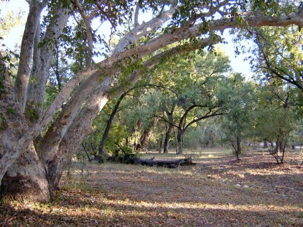
Photo Point 136, floodplain of Turkey Creek, Happy Valley, Rincons, 4000 feet, September 2008. The unseen creek is to the left of the co-dominants sycamore (20 m) and Emory oak (15m). Each give 15-24% cover. Common associates include walnut, ash, hackberry, red berry juniper, and mesquite. The area was recently grazed, and grasses were cropped.
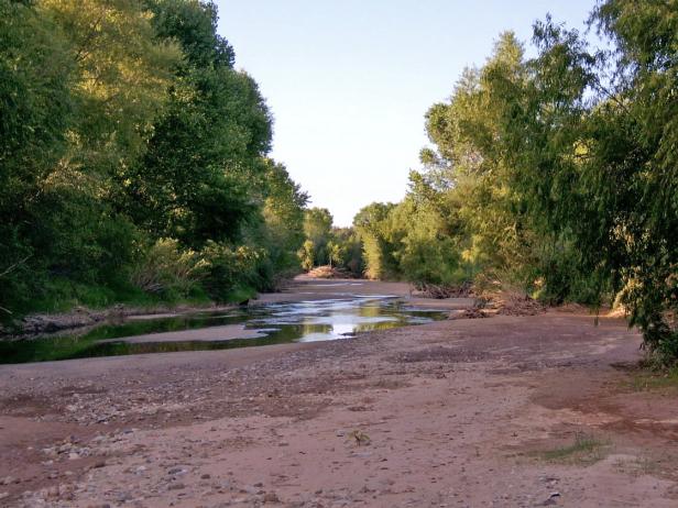
Photo Point 63, showing a gallery forest of cottonwood and willow along a perennial stretch of the San Pedro River, 18 miles north of Benson, 3200 feet, September 2007. Like the Rillito River at Tucson, the San Pedro north of the town of Benson is mostly dry, and much of the mesquite bosque woodland on the floodplain is now agriculture or housing. However, around fifteen miles north of Benson, at “The Narrows,” the river begins a perennial stretch of several miles, as shown in the photo. The tallest trees are 15 meter cottonwood and willow. The banks are mostly Bermuda grass, seep willow, and young Tamarix. The floodplain is abandoned alfalfa fields, thick with tumbleweed and Solanum after the summer rains.
Desired Conditions
Desired conditions are adapted from Riparian, mid-scale desired condition statements in March 2010 Coronado National Forest planning documents.
Channels and their adjacent floodplains are capable of filtering sediment, capturing bedload, aiding floodplain development, improving flood-water retention, and increasing ground-water recharge. Vegetation and root masses stabilize streambanks against the cutting action of water currents. The ecological condition of riparian areas is resilient to animal and human use. Tree canopy cover is between 30 and 100 percent. Soil banks are 70- to 100-percent occupied by vegetation.
Where water is perennial, stream flows and water quality characteristics support aquatic wildlife. Native fish and other aquatic species are present, and habitat conditions are capable of providing self-sustaining populations. Native fish and amphibian populations are free from or minimally impacted by non-native predation and diseases. Habitat and ecological conditions are capable of providing self-sustaining populations of native, riparian-dependent plant and animal species. Fire rarely burns through this vegetation type, and fire in the surrounding watershed periodically provides slight increases in sediment and water that cause minimal channel modification.
Historic Mean Fire Return Interval (Schussman et al. 2006 literature review)
Infrequent (similar to adjacent fire regimes) for riparian areas
Primary treatment options:
- No primary treatments intended
Secondary treatment options (estimated representative project size range):
- Wildland fire: prescribed fire and/or wildfire to maintain openings, reduce ground fuels, and site prep (1,000 to 30,000 acres per project)
- Thinning to reduce fuel loading (up to 500 acres per project)
Other Vegetation Classifications: