Upper Sonoran desert on hills and mountains of sedimentary, metasedimentary, and extrusive rocks
The bulk of this EU follows a NW-SE trending band of complicated lithology along the east side of Redington Pass and the Rincons. Most of the unit is Paleozoic sedimentary rocks, from limestone to siltstone, but there are also inclusions of Cenozoic volcanics. These latter areas were not visited, and were included in this EU for a lack of a better category; they may well be different.
A second swatch of this EU follows a similar NW-SE trend, except on the west side of the Rincons, from Colossal Cave to the Tanque Verde Ridge foothills. Limestone is the dominant rock, but there is also quartzite (near Pistol Hill) and conglomerate (near Cienega Creek).
For those areas visited, the prevailing vegetation was whitethorn, palo verde, and prickly pear, for a total of 15-25% cover. On the west side of the Rincons, the small shrub mariola was often a co-dominant. Grasses were typically 5% or less cover. Saguaros were typical on warm slopes, while juniper appeared on north slopes. Several perennial stretches of water are within the EU, in Buehman, Espiritu, Youtcy and Edgar Canyons, each supporting cottonwood, ash, and sycamore.
Elevations range from 900 m (2900 ft) to 1500 m (4875 ft). The higher elevations are a small fraction of the EU (Piety Hill in Redington Pass, and the ridge above Posta Quemada Canyon), above “Upper Sonoran” vegetation, but included here because of similarities with bedrock geology. About 46% of the EU is level or rolling hills; while the remainder is slopes exceeding 18%; of the latter, about 10% is very steep, with over 70% slope.
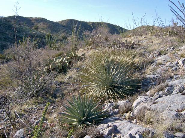
Photo Point 11, Redington Pass near Piety Hill, 4100 feet, March 2008. Whitethorn and prickly pear are the dominants on limestone, with each giving 1-4% cover. Fairyduster and ocotillo are common associates. Grasses are thin, less than 5%, and at this site mostly annual three-awn. Junipers are on the slope in the background. Blue palo verde are present but uncommon.
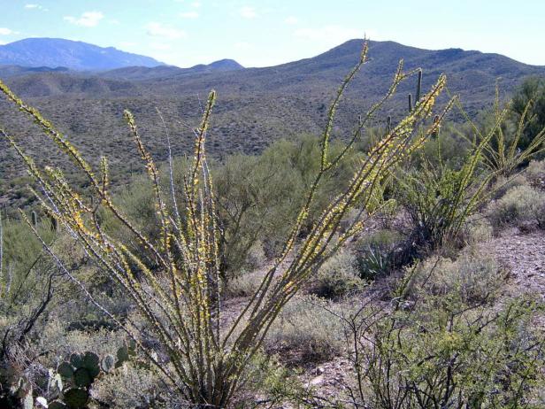
Photo Point 123, about 3 miles SW of Redington, in the hills above Buehman Canyon, looking SW to Piety Hill and Mica Mt. 3600 feet, September, 2008. The substrate at this location varies from the Bisbee group (siltstone, sandstone, and conglomerate) to limestone, and the vegetation also varied. Yet the keynote species remained the foothill paloverde, which at the photo station was co-dominant with the shrub mariola. Saguaros are common. Both gave about 1-14% cover. Common associates include whitethorn, fairy duster, and prickly pear (each with 5-9%). Ocotillo, banana yucca, and oraganillo each gave another 1-4% cover. Grasses, mostly fluffgrass and slim tridens, added another 5% cover.
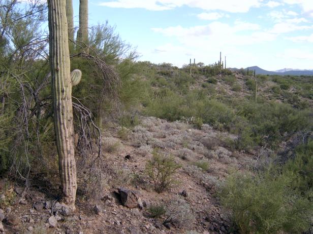
Photo Point 48, Tanque Verde Ridge, Rincons, Saguaro NP, 3200 feet, September 2007. A patch of brittlebush are in the midground, while foothill paloverde and whitethorn dominate the background. At lower elevations within the EU, the dominant vegetation includes mariola and creosote bush. Common associates include Mexican crucillo, croton, paperflower, ocotillo, and hackberry bush. Saguaro is common, mesquite is uncommon, and jojoba bush is absent. Common bunchgrasses include bush muhly and tanglehead.
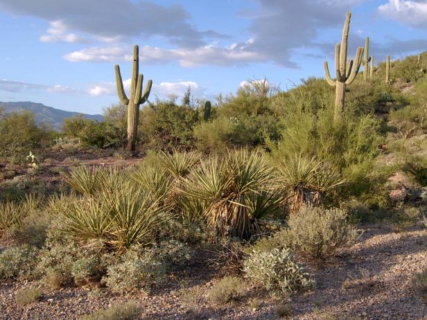
Photo Point 82, near Colossal Cave, 3700 feet, September 2008. On a slope below limestone bluffs, a patch of banana yucca is encircled by mariola, the local dominant, with 5-9% cover. Common associates, each giving another 1-4% cover, include brittlebush, whitethorn, banana yucca, oraganillo, saguaro, and foothill paloverde. Hairy grama, the most common grass, adds another 1-4%.
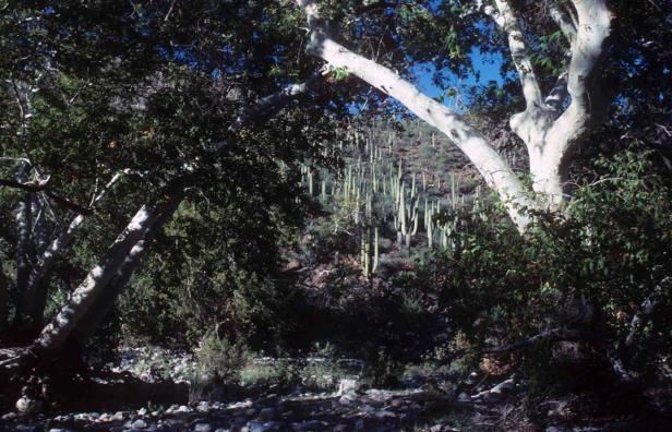
Photo Point 113, Redington Pass, Buehman canyon. Photo from circa 1990, showing saguaros on south facing slope above riparian corridor of sycamore. 3200 feet.
Desired Conditions
Desired conditions are adapted from Desert, mid-scale desired condition statements in March 2010 Coronado National Forest planning documents.
On moderately steep hillsides and fan piedmont where alkaline soils are formed in alluvium from mixed parent materials, the predominant species are foothill paloverde, saguaro, prickly pear, cholla, barrel cactus, ocotillo, false mesquite, triangleleaf bursage, bush muhly, slender grama, curly mesquite, spidergrass, tangelhead, purple threeawn, janusia, ayenia and globe mallow. Annual forbs and grasses, an important part of this plant community, fluctuate with precipitation from nearly nothing in dry years to several hundred pounds per acre in wet years. Plant basal cover ranges from 1 to 3 percent, and cover by plant litter ranges from 10 to 75 percent. Canopy cover ranges from 1 to 20 percent for grasses, 1 to 15 percent for forbs, and 5 to 20 percent for shrubs and succulents. Tree canopy cover is 1 to 10 percent.
On moderately steep hillsides and fan piedmont where non-alkaline soils are formed in alluvium from mixed parent materials, the predominant species are foothill paloverde, saguaro, prickly pear, cholla, ocotillo, whitethorn acacia, creosote bush, false mesquite, range ratany, desert zinnia, bush muhly, black grama, slim tridens, fluff grass, janusia, desert senna, and twinberry. Annual forbs and grasses, an important part of this plant community, fluctuate with precipitation from nearly nothing in dry years to several hundred pounds per acre in wet years. Plant basal cover ranges from 1 to 3 percent, and cover by plant litter ranges from 5 to 45 percent. Canopy cover ranges from 1 to 10 percent for grasses, 1 to 10 percent for forbs, and 5 to 20 percent for shrubs and succulents. Tree canopy cover is 1 to 10 percent.
On nearly level floodplains, low stream terraces and canyon bottoms where soils are formed in recent alluvium from mixed parent materials, the predominant species are foothill and blue paloverde, mesquite, catclaw acacia, desert willow, desert hackberry, wolfberry, big bursage, burrobrush, desert honeysuckle, bush muhly, sand and spike dropseed, sideoats grama, tanglehead, spidergrass, and mesa threeawn. Annual forbs and grasses fluctuate with precipitation from nearly nothing in dry years to several hundred pounds per acre in wet years. Plant basal cover ranges from 2 to 5 percent, and cover by plant litter ranges from 5 to 45 percent. Canopy cover ranges from 10 to 20 percent for grasses, 1 to 15 percent for forbs, and 5 to 15 percent for shrubs and succulents. Tree canopy cover is 10 to 15 percent.
Historic Mean Fire Return Interval (Schussman et al. 2006 literature review)
> 250 years for warm desert communities
Primary treatment options (estimated representative project size range):
- Mechanical treatments for fuel reduction and to maintain openings (up to 2,500 acres per project)
- Herbicide treatment for exotics and shrub management to maintain openings and reduce fire spread (up to 1,000 acres per project)
Supplemental treatment option (estimated representative project size range):
- Thinning around developments for safety-related fuel reduction (up to 500 acres per project)
Other Vegetation Classifications: