Mesquite/juniper grasslands on hills and mountains of various lithologies
Most of this EU is scattered by the complex geology on the east side of Rincons, with a couple of exceptions on the north end of the Catalinas. The land is mostly schist, monzonite, quartzite, and granitic rocks, and it’s rolling country, with 71% of the land exceeding 18% slope. Mesquite and juniper are the most common trees, each with typically 10-14% cover, but blue oak can also be common on north slopes, and wait-a-minute bush and/or catclaw is occasionally co-dominant. Juniper is occasionally absent. Grasses generally make up 25-39% of the ground cover, but the number can drop off dramatically on south slopes or after drought.
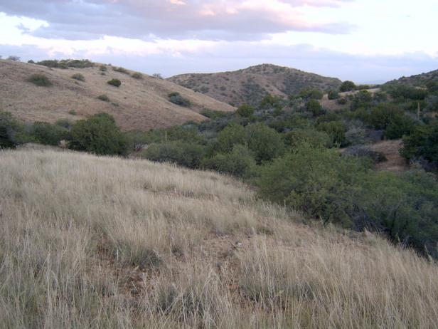
Photo Point 192, Catalinas, 4800 feet, October 2008, along Oracle Control Road, about 1 mile south of Peppersauce Canyon. The trees are mostly mesquite and juniper, each with about 10-14% cover. The grasses on the south facing slope are mostly Lehmnan’s love grass and tanglehead.
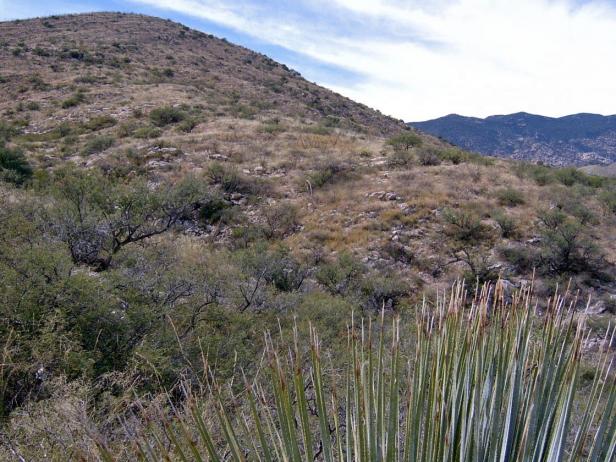
Photo Point 74, Rincons, looking NW towards Happy Valley Saddle, 4000 feet, October 2008. On this slope of schist and quartz monzonite, mesquite and wait-a-minute co-dominate, each with a cover of 10-14%. There are no junipers nearby, but blue oak was noted upslope. Love grass and tanglehead gave another 1–14% cover.
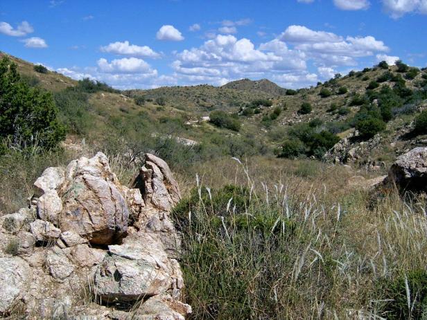
Photo Point 119, Redington Road, in hills about one mile west of turnoff to A-7 Ranch, 4200 ft. Juniper and blue oak dominate, each with 5-9% cover. Common associates include beargrass, emory oak, manzanita, and mesquite.
Desired Conditions
Desired conditions are adapted from Semi-desert grassland, mid-scale in March 2010 Coronado National Forest planning documents.
On steep hillslopes and ridgetops where soils have formed in place on acid igneous and metamorphic parent materials like granite, rhyolite, gneiss, schist and quartzite, the potential native plant community is dominated by perennial grasses and sub-shrubs with lesser amounts of large shrubs and succulents. The predominant species are black, sideoats, slender, sprucetop, Santa Rita and hairy gramas, tanglehead, cane beardgrass, plains lovegrass, ocotillo, sotol, kidneywood, mimosa species, false mesquite, shrubby buckwheat, dalea, shin-dagger, agave, wire lettuce, penstemon, herbaceous sage, and ferns. Plant basal cover ranges from 5 to 12 percent, and cover by plant litter ranges from 25 to 40 percent. Canopy cover ranges from 20 to 50 percent for perennial grasses, 1 to 10 percent for forbs, and 10 to 15 percent for shrubs and succulents. Tree canopy cover is 0 to 2 percent and may include species like one-seed juniper, mesquite, and Arizona rosewood.
On moderately sloping pediments where soils have formed in place on acid igneous and metamorphic parent materials like granite, gneiss, schist and rhyolite, the potential native plant community is dominated by perennial grasses and sub-shrubs with lesser amounts of large shrubs and succulents. The predominant species are black, sideoats, slender, sprucetop, Santa Rita and hairy gramas, tanglehead, Arizona muhly, curly mesquite, ocotillo, false mesquite, range and spreading ratany, shrubby buckwheat, dalea, agave, mimosa species, wire lettuce, penstemon, trailing four o’clock, spike moss, and shrubby deervetch. Plant basal cover ranges from 6 to 15 percent, and cover by plant litter ranges from 25 to 40 percent. Canopy cover ranges from 20 to 50 percent for perennial grasses, 0 to 3 percent for forbs, and 10 to 25 percent for shrubs and succulents. Tree canopy cover is 0 to 2 percent and may include species like one-seed juniper and mesquite.
On steep hillslopes, ridgetops, and mesas where soils have formed in place on basic and intermediate igneous parent materials like basalt, andesite and welded volcanic tuff and ash, the plant community is dominated by native perennial grasses with lesser amounts of shrubs and succulents. The predominant species are sideoats grama, cane beardgrass, plains lovegrass, green sprangletop, purple and hairy gramas, curly mesquite, tanglehead, ocotillo, mimosa species, false mesquite, shrubby buckwheat, shin-dagger, agave, prickly pear, penstemon, bluedicks, herbaceous sage, globe mallow, and ferns. Plant basal cover ranges from 5 to 15 percent, and cover by plant litter ranges from 25 to 55 percent. Canopy cover ranges from 25 to 65 percent for perennial grasses, 1 to 10 percent for forbs, and 5 to 15 percent for shrubs and succulents. Tree canopy cover is 0 to 2 percent and may include species like one-seed juniper, mesquite and netleaf hackberry.
On steep hillslopes and ridgetops where soils have formed in place on limestone parent materials, the plant community is dominated by native perennial grasses, shrubs and succulents. The predominant species are sideoats grama, black grama, slim tridens, tanglehead, Hall’s panic, New Mexico feathergrass, ocotillo, mariola, false mesquite, feather dalea, whitethorn acacia, sandpaper bush, creosote bush, twinberry, stool, shin-dagger, banana yucca, prickly pear, bahia, dogweed, croton, bladdderpod, and ferns. Plant basal cover ranges from 3 to 8 percent, and cover by plant litter ranges from 10 to 25 percent. Canopy cover ranges from 15 to 30 percent for perennial grasses, 1 to 10 percent for forbs, and 15 to 40 percent for shrubs and succulents. Tree canopy cover is 0 to 5 percent and may include species like one-seed juniper, mesquite and rosewood.
On moderately steep hillsides and fan piedmont where soils have formed in loamy alluvium from mixed sources, the plant community is dominated by native perennial grasses and sub-shrubs with lesser amounts of large shrubs and succulents. The predominant species are sideoats, slender, black, sprucetop and hairy gramas, tanglehead, cane beardgrass, plains lovegrass, wolftail, spidergrass, purple threeawn, false mesquite, range ratany, shrubby buckwheat, agave, prickly pear, barrel cactus, banana yucca, globe mallow, bluedicks, and wire lettuces. Plant basal cover ranges from 6 to 15 percent, and cover by plant litter ranges from 10 to 50 percent. Canopy cover ranges from 20 to 60 percent for perennial grasses, 1 to 15 percent for forbs, and 2 to 20 percent for shrubs and succulents. Tree canopy cover is 0 to 1 percent and may include species like one-seed juniper, catclaw acacia and mesquite.
On moderately steep hillsides, fan piedmont, and ballenas where soils have formed in coarse loamy, calcareous alluvium and colluviums, the plant community is dominated by native perennial grasses, shrubs and succulents. The predominant species are sideoats grama, black grama, bush muhly, slim tridens, shortleaf tridens, tanglehead, Hall’s panic, spike pappusgrass, blue threeawn, ocotillo, condalia, mariola, false mesquite, range ratany, feather dalea, Wright’s beebrush, mormon tea, twinberry, desert zinnia, banana yucca, prickly pear, bahia, dogweed, croton, paperflower, and trailing four o’clock. Plant basal cover ranges from 6 to 15 percent, and cover by plant litter ranges from 10 to 50 percent. Canopy cover ranges from 20 to 60 percent for perennial grasses, 1 to 5 percent for forbs, and 5 to 30 percent for shrubs and succulents. Tree canopy cover is 0 to 1 percent and may include species like one-seed juniper and mesquite.
On nearly level floodplains, low stream terraces and canyon bottoms where soils are formed in recent alluvium from mixed parent materials, the plant community is dominated by native trees and shrubs with lesser amounts of perennial grasses, vines, and forbs. The predominant species are mesquite, catclaw acacia, desert willow, blue paloverde, netleaf hackberry, western soapberry, burrobrush, desert honeysuckle, clematis, greythorn, sacaton, bush muhly, sand and spike dropseed, sideoats grama, tanglehead, green sprangletop, plains bristlegrass, spidergrass, mesa threeawn, coyote melon, canaigre, pigweed, morning-glory, ragweed, and wishbone bush. Plant basal cover ranges from 6 to 17 percent, and cover by plant litter ranges from 30 to 75 percent. Canopy cover ranges from 15 to 50 percent for grasses, 1 to 15 percent for forbs, and 2 to 20 percent for shrubs and succulents. Tree canopy cover ranges from 15 to 30 percent.
Historic Mean Fire Return Interval (Schussman et al. 2006 literature review)
2.5-10 years for semi-desert grassland
Primary treatment options (estimated representative project size range):
- Wildland fire: Prescribed fire and/or wildfire to maintain openings, reduce ground fuels, and site prep (1,000 to 30,000 acres per project)
- First-entry mechanical treatments to prepare for fire reintroduction (mastication/crushing, pushing, thinning) (up to 2,500 acres per project)
Secondary treatment options (estimated representative project size range):
- Thinning around developments for safety-related fuel reduction and lop and scatter brush along trails (up to 500 acres per project)
- Herbicide and mechanical treatment for exotics and shrub management and to maintain openings (up to 1,000 acres per project)
- Fuelwood sales (smaller diameter, including aspens) to reduce fuel loading (up to 300 acres per project)