Mesquite grasslands on fans, terraces, and weakly consolidated pediments of various parent materials
This large EU is composed of 8 LTAs stretched out along the east and south sides of the study area, between 3000 and 4500 feet. About 1/3 of the EU is flat, 1/3 is gentle slopes, and 1/3 is steep to very steep slopes.
Mesquite and grasses are the dominant vegetation. The mesquite are typically 3 m tall, with 5-14% cover, occasionally to 40% in swales, where its common associate is tobosa grass. On rockier sites, the most common associate is prickly pear, which is often co-dominant. On steep north-facing slopes there can be redberry juniper and blue oak, but generally at less than 14% cover.
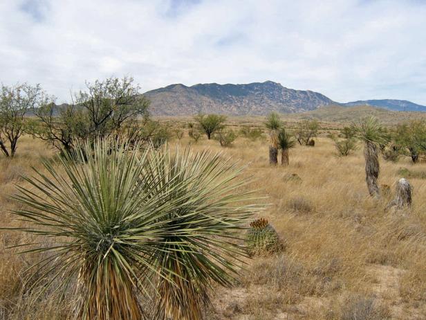
Photo Point 73, 4 miles north of Mescal Jct., looking NW to Rincon Peak. September, 2007, 4000 feet. Photo is taken from a rise. Nearby swales held more mesquite and tobosa grass.
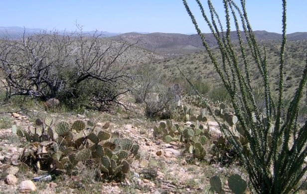
Photo Point 16, east side of Catalinas, the view south from a point between Davis Mesa and Buehman Canyon, 3500 feet, March 2008. Mesquite and prickly pear co-dominant, each with 5-9% cover. Whitethorn is a common associate with 1-4% cover. At its lowest elevations near Buehman, there are scattered blue palo verde and saguaro. Tobosa, love grass, and six-weeks three awn are common grasses, but with under 5% cover.
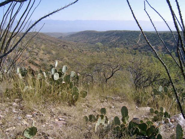
Photo Point 222, East side of Catalinas, mesa above Peppersauce Canyon, 4300 ft. Oct. 2008. Mesquite and prickly pear each with 10-14% cover. Common grasses, each with 5-9% cover, include plains lovegrass, tobosa, spider grass, and bristle grass. On north-facing slopes above the canyon, oak and juniper can reach 10-14% cover.
Desired Conditions
Desired conditions are adapted from Semi-desert grasslands, mid-scale desired condition statements in March 2010 Coronado National Forest planning documents.
On steep hillslopes and ridgetops where soils have formed in place on acid igneous and metamorphic parent materials like granite, rhyolite, gneiss, schist and quartzite, the potential native plant community is dominated by perennial grasses and sub-shrubs with lesser amounts of large shrubs and succulents. The predominant species are black, sideoats, slender, sprucetop, Santa Rita and hairy gramas, tanglehead, cane beardgrass, plains lovegrass, ocotillo, sotol, kidneywood, mimosa species, false mesquite, shrubby buckwheat, dalea, shin-dagger, agave, wire lettuce, penstemon, herbaceous sage, and ferns. Plant basal cover ranges from 5 to 12 percent, and cover by plant litter ranges from 25 to 40 percent. Canopy cover ranges from 20 to 50 percent for perennial grasses, 1 to 10 percent for forbs, and 10 to 15 percent for shrubs and succulents. Tree canopy cover is 0 to 2 percent and may include species like one-seed juniper, mesquite, and Arizona rosewood.
On moderately sloping pediments where soils have formed in place on acid igneous and metamorphic parent materials like granite, gneiss, schist and rhyolite, the potential native plant community is dominated by perennial grasses and sub-shrubs with lesser amounts of large shrubs and succulents. The predominant species are black, sideoats, slender, sprucetop, Santa Rita and hairy gramas, tanglehead, Arizona muhly, curly mesquite, ocotillo, false mesquite, range and spreading ratany, shrubby buckwheat, dalea, agave, mimosa species, wire lettuce, penstemon, trailing four o’clock, spike moss, and shrubby deervetch. Plant basal cover ranges from 6 to 15 percent, and cover by plant litter ranges from 25 to 40 percent. Canopy cover ranges from 20 to 50 percent for perennial grasses, 0 to 3 percent for forbs, and 10 to 25 percent for shrubs and succulents. Tree canopy cover is 0 to 2 percent and may include species like one-seed juniper and mesquite.
On steep hillslopes, ridgetops, and mesas where soils have formed in place on basic and intermediate igneous parent materials like basalt, andesite and welded volcanic tuff and ash, the plant community is dominated by native perennial grasses with lesser amounts of shrubs and succulents. The predominant species are sideoats grama, cane beardgrass, plains lovegrass, green sprangletop, purple and hairy gramas, curly mesquite, tanglehead, ocotillo, mimosa species, false mesquite, shrubby buckwheat, shin-dagger, agave, prickly pear, penstemon, bluedicks, herbaceous sage, globe mallow, and ferns. Plant basal cover ranges from 5 to 15 percent, and cover by plant litter ranges from 25 to 55 percent. Canopy cover ranges from 25 to 65 percent for perennial grasses, 1 to 10 percent for forbs, and 5 to 15 percent for shrubs and succulents. Tree canopy cover is 0 to 2 percent and may include species like one-seed juniper, mesquite and netleaf hackberry.
On steep hillslopes and ridgetops where soils have formed in place on limestone parent materials, the plant community is dominated by native perennial grasses, shrubs and succulents. The predominant species are sideoats grama, black grama, slim tridens, tanglehead, Hall’s panic, New Mexico feathergrass, ocotillo, mariola, false mesquite, feather dalea, whitethorn acacia, sandpaper bush, creosote bush, twinberry, stool, shin-dagger, banana yucca, prickly pear, bahia, dogweed, croton, bladdderpod, and ferns. Plant basal cover ranges from 3 to 8 percent, and cover by plant litter ranges from 10 to 25 percent. Canopy cover ranges from 15 to 30 percent for perennial grasses, 1 to 10 percent for forbs, and 15 to 40 percent for shrubs and succulents. Tree canopy cover is 0 to 5 percent and may include species like one-seed juniper, mesquite and rosewood.
On moderately steep hillsides and fan piedmont where soils have formed in loamy alluvium from mixed sources, the plant community is dominated by native perennial grasses and sub-shrubs with lesser amounts of large shrubs and succulents. The predominant species are sideoats, slender, black, sprucetop and hairy gramas, tanglehead, cane beardgrass, plains lovegrass, wolftail, spidergrass, purple threeawn, false mesquite, range ratany, shrubby buckwheat, agave, prickly pear, barrel cactus, banana yucca, globe mallow, bluedicks, and wire lettuces. Plant basal cover ranges from 6 to 15 percent, and cover by plant litter ranges from 10 to 50 percent. Canopy cover ranges from 20 to 60 percent for perennial grasses, 1 to 15 percent for forbs, and 2 to 20 percent for shrubs and succulents. Tree canopy cover is 0 to 1 percent and may include species like one-seed juniper, catclaw acacia and mesquite.
On moderately steep hillsides, fan piedmont, and ballenas where soils have formed in coarse loamy, calcareous alluvium and colluviums, the plant community is dominated by native perennial grasses, shrubs and succulents. The predominant species are sideoats grama, black grama, bush muhly, slim tridens, shortleaf tridens, tanglehead, Hall’s panic, spike pappusgrass, blue threeawn, ocotillo, condalia, mariola, false mesquite, range ratany, feather dalea, Wright’s beebrush, mormon tea, twinberry, desert zinnia, banana yucca, prickly pear, bahia, dogweed, croton, paperflower, and trailing four o’clock. Plant basal cover ranges from 6 to 15 percent, and cover by plant litter ranges from 10 to 50 percent. Canopy cover ranges from 20 to 60 percent for perennial grasses, 1 to 5 percent for forbs, and 5 to 30 percent for shrubs and succulents. Tree canopy cover is 0 to 1 percent and may include species like one-seed juniper and mesquite.
On nearly level floodplains, low stream terraces and canyon bottoms where soils are formed in recent alluvium from mixed parent materials, the plant community is dominated by native trees and shrubs with lesser amounts of perennial grasses, vines, and forbs. The predominant species are mesquite, catclaw acacia, desert willow, blue paloverde, netleaf hackberry, western soapberry, burrobrush, desert honeysuckle, clematis, greythorn, sacaton, bush muhly, sand and spike dropseed, sideoats grama, tanglehead, green sprangletop, plains bristlegrass, spidergrass, mesa threeawn, coyote melon, canaigre, pigweed, morning-glory, ragweed, and wishbone bush. Plant basal cover ranges from 6 to 17 percent, and cover by plant litter ranges from 30 to 75 percent. Canopy cover ranges from 15 to 50 percent for grasses, 1 to 15 percent for forbs, and 2 to 20 percent for shrubs and succulents. Tree canopy cover ranges from 15 to 30 percent.
Fire plays a key role in maintaining the grasslands, with large, low intensity fires usually occurring in the early summer, every 2.5 to 10 years. These fires reduce shrub cover while having little negative effect on grasses. The ability of soil to maintain resource values and sustain outputs is high.
Historic Mean Fire Return Interval (Schussman et al. 2006 literature review)
2.5-10 years for semi-desert grassland
Primary treatment options (estimated representative project size range):
- Wildland fire: Prescribed fire and/or wildfire to maintain openings, reduce ground fuels, and site prep (1,000 to 30,000 acres per project)
- First-entry mechanical treatments to prepare for fire reintroduction (mastication/crushing, pushing, thinning) (up to 2,500 acres per project)
Secondary treatment options (estimated representative project size range):
- Thinning around developments for safety-related fuel reduction and lop and scatter brush along trails (up to 500 acres per project)
- Herbicide and mechanical treatment for exotics and shrub management and to maintain openings (up to 1,000 acres per project)
- Fuelwood sales (smaller diameter, including aspens) to reduce fuel loading (up to 300 acres per project)
Other vegetation classifications:
Ecological System as defined by the Southwest Regional Gap Analysis Project
Biome after Brown, Lowe and Pase (1979)
143.1 Scrub-Grassland (Semidesert Grassland)
Mid-scale Dominance Type (USFS Coronado NF GIS)
Community after Whittaker and Niering (1975)
Desert grassland