Upper Sonoran desert on hills and mountains derived from granite, gneiss, and similar rocks
This EU forms a continuous band along the south and west sides of the Catalina and Rincon Mountains, as well as the lower elevations of Tanque Verde Ridge. About 61% of the land exceeds an 18% slope, and 13% of the total exceeds a very steep 70% slope. Elevations range from 830 m (2700 ft) to 1550 m (5000 ft).
On these rocky soils, the dominant tree is usually foothill palo verde, usually only 2 to 3 m tall, and giving 5-9% cover. But the smaller (1.5-2 m) and wispier ‘samota’ (Coursetia glandulosa) is widespread and occasionally dominant. Likewise, the shrub oreganillo is often abundant. This EU also includes many riparian corridors of lovely canyon bottom, alternating between steep boulder piles and pockets of cottonwood and willow.
Native grasses can be common but rarely exceed 10% cover. Buffel grass, in contrast, has achieved around 50% cover in some heavily infested areas, such as Soldier Canyon.
The portion of the EU south of the Rincon Valley was not visited except by binoculars from a distance. An old Saguaro NP vegetation map marks this as ‘semi-desert chaparral.’ Palo verde and saguaro appear to be restricted to warm slopes, with mesquite and grasses elsewhere. With regard to fire, the tree cover and height appears similar to the rest of the EU, but with more than 10% grass. Without further sampling, we won’t know precisely how much more.
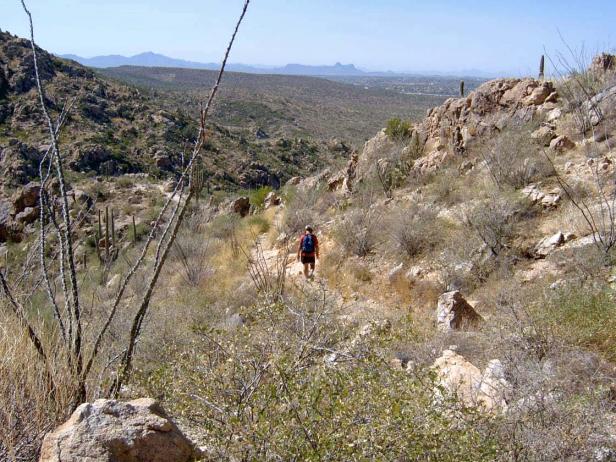
Photo Point 205, Montrose Canyon, Catalinas, 3200 feet, October, 2008. This south-facing slope is dominated by samota (Coursetia glandulosa), averaging 2 m in height and with 5-9% cover. Fairyduster is a close second, also with 5-9% cover. Common associates with 1-4% cover include palo verde, saguaro, and brittlebush. Grasses are common, too, with plains lovegrass, purple three-awn and six-weeks three awn giving an additional 5-9% cover.
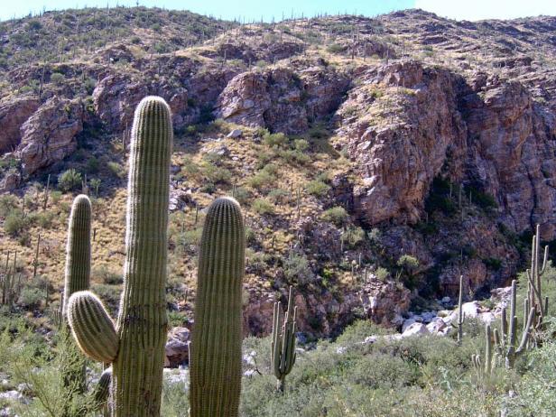
Photo Point 145, above Soldier Canyon at this first hairpin curve on the Catalina Highway, 3200 feet, October, 2008. On the foreground slope, facing west, oreganillo (0.6 m), foothill palo verde (2m) and brittlebush (0.6 m) are the dominants, each with 10-14% cover. The background slope, facing the camera, is heavily infested with buffelgrass, with 40-59% cover. In contrast, the spider grass, bush muhly, and cane bluestem grasses on the foreground slope give a total of 5-9% cover. Saguaro and fairy duster are common associates, each with 1-4% cover.
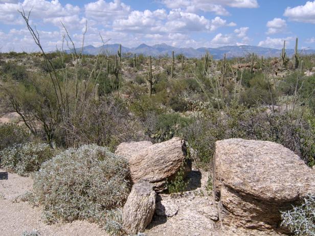
Photo Point 52, near the Javelina picnic ground in Saguaro National Park, 3100 feet. The saguaro is the standout, but in terms of cover the dominants are brittlebush and prickly pear cactus, each with 5-9% cover. Common associates, each with 1-4% cover, include foothill paloverde, mesquite, ocotillo, fairyduster, limberbush, and a variety of cholla cactus. Jojoba is highly variable, and occasionally co-dominant. Two miles north, near the park visitor center, whitethorn is a common species; only a half-mile south, on a steep north-facing slope, the shrub oreganillo is common while jojoba vanishes.
Desired Conditions
Desired conditions are adapted from Desert, mid-scale desired condition statements in March 2010 Coronado National Forest planning documents.
On moderately steep hillsides and fan piedmont where alkaline soils are formed in alluvium from mixed parent materials, the predominant species are foothill paloverde, saguaro, prickly pear, cholla, barrel cactus, ocotillo, false mesquite, triangleleaf bursage, bush muhly, slender grama, curly mesquite, spidergrass, tangelhead, purple threeawn, janusia, ayenia and globe mallow. Annual forbs and grasses, an important part of this plant community, fluctuate with precipitation from nearly nothing in dry years to several hundred pounds per acre in wet years. Plant basal cover ranges from 1 to 3 percent, and cover by plant litter ranges from 10 to 75 percent. Canopy cover ranges from 1 to 20 percent for grasses, 1 to 15 percent for forbs, and 5 to 20 percent for shrubs and succulents. Tree canopy cover is 1 to 10 percent.
On moderately steep hillsides and fan piedmont where non-alkaline soils are formed in alluvium from mixed parent materials, the predominant species are foothill paloverde, saguaro, prickly pear, cholla, ocotillo, whitethorn acacia, creosote bush, false mesquite, range ratany, desert zinnia, bush muhly, black grama, slim tridens, fluff grass, janusia, desert senna, and twinberry. Annual forbs and grasses, an important part of this plant community, fluctuate with precipitation from nearly nothing in dry years to several hundred pounds per acre in wet years. Plant basal cover ranges from 1 to 3 percent, and cover by plant litter ranges from 5 to 45 percent. Canopy cover ranges from 1 to 10 percent for grasses, 1 to 10 percent for forbs, and 5 to 20 percent for shrubs and succulents. Tree canopy cover is 1 to 10 percent.
On nearly level floodplains, low stream terraces and canyon bottoms where soils are formed in recent alluvium from mixed parent materials, the predominant species are foothill and blue paloverde, mesquite, catclaw acacia, desert willow, desert hackberry, wolfberry, big bursage, burrobrush, desert honeysuckle, bush muhly, sand and spike dropseed, sideoats grama, tanglehead, spidergrass, and mesa threeawn. Annual forbs and grasses fluctuate with precipitation from nearly nothing in dry years to several hundred pounds per acre in wet years. Plant basal cover ranges from 2 to 5 percent, and cover by plant litter ranges from 5 to 45 percent. Canopy cover ranges from 10 to 20 percent for grasses, 1 to 15 percent for forbs, and 5 to 15 percent for shrubs and succulents. Tree canopy cover is 10 to 15 percent.
Historic Mean Fire Return Interval (Schussman et al. 2006 literature review)
> 250 years for warm desert communities
Primary treatment options (estimated representative project size range):
- Mechanical treatments for fuel reduction and to maintain openings (up to 2,500 acres per project)
- Herbicide treatment for exotics and shrub management to maintain openings and reduce fire spread (up to 1,000 acres per project)
Supplemental treatment option (estimated representative project size range):
- Thinning around developments for safety-related fuel reduction (up to 500 acres per project)
Other Vegetation Classifications: