Madrean pine-oak forest/woodland on mountains derived from granite, gneiss, and similar rocks
Between the oak grassland/woodland and the ponderosa pine basins are the steep canyons of both pine and oak. Elevations range from 1500 m (4875 ft) to 2760 m (8677 ft). About 91% of this EU is greater than an 18% slope, a figure that includes the 19% that is steeper than 70% slope. The steeper the slope, the greater the effect of aspect, which is one reason why this EU is characterized by Ponderosa and Chihuahuan pine on north facing slopes, (particularly in drainages), and silverleaf/netleaf oak thickets on south facing slopes. Of course most slopes are something between due north and south, and the result is a mosaic, much like Photo Point 258 below.
This wet/dry distribution makes it difficult to generalize the coverage of any one species over the entire EU. However it is reasonable to say that among the higher elevations of the EU, above 7000 feet, the most mesic slopes are mostly pine and occasional Douglas fir, typically 10-15m tall, and with a combined total cover of 25-39%. Xeric habitat is typically silverleaf/netleaf oak, 2 to 4m tall (depending on when it last burned), with 25-39% cover. Manzanita is a common associate, often with 10-14% cover. Both mesic and xeric slopes typically hold little or no grasses on the rather mobile slopes of decomposed granite and gneiss. Any relatively flat ground, however, typically supports bullgrass with 1-4% cover.
Below 7000 feet, pinyon pine, averaging 5 m tall and typically with 25-39% cover, can also be common and occasionally co-dominant (see Photo Point 94, below). This is especially so in the Rincons. Pinyon pine doesn’t resprout, and tend to be in very rocky (or lucky) habitat that have escaped fires over the last century. Juniper, with stature and coverage similar to the pinyon, can also be common and/or dominant, and seems to prefer deeper soils on more level terrain (as in lower Canada del Oro), or along ridges like Oracle and Samaniego Ridge, often in company of manzanita (Near Walnut Spring and Samaniego Peak, says author Pete Cowgill, is an alligator juniper snag over 8 feet in diameter).
But pinyon and juniper are more often subdominant to the oaks at lower elevations. Besides the silverleaf and netleaf on slopes, Arizona white oak and Emory oak are common on flatter aspects. The latter two species typically exceed 10 m in height along canyon bottoms, but are only 3 to 5 m tall elsewhere. Overall cover still hovers in the 24-39% range. The larger pines are uncommon, in isolated pockets and canyons (Photo Point 94, below, from Happy Valley).
Also noted: (1) This EU was, among all EUs, the hardest hit by the Aspen and Bullock fires. (2) The EU holds a large relict population of cypress in Bear Canyon. (3) In the Firescape scheme, landscapes that are mostly rock outcrops are placed in the EU called “Madrean oak/conifer/manzanita on hills and mountains with extensive rock outcrops”. Much of that EU has vegetation similar to this pine-oak EU, and the two units often border one another.
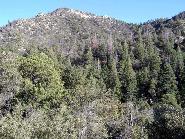
Photo Point 147, Upper Bear Canyon, as seen from the slope above General Hitchcock Campground, 6000 feet, October 2008. The foreground vegetation, on a south-facing slope, is silverleaf oak, typically 2.3 m tall and with 25-39% cover. Common associates include manzanita (1.3 m, 10-14%), Ceanothus fendleri (1 m, 5-9%), and bullgrass (0.7 m, 5-9%). Species with 1-4% cover include alligator juniper (2 m), Arizona oak (2.3 m), Emory oak (2.3 m), and bear grass (1 m). The opposite slope holds doug fir and ponderosa, mixed with oak on ridgelines.
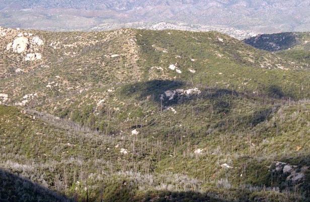
Photo Point 54, Rincons, looking NE from Mica Secondary to the headwaters of Tanque Verde Wash in ELT 13c, 8300 feet, September 2008. This area was burned twice in the last 15 years, and the difference in regrowth is visible in the photo center. The tall dead trees were primarily Ponderosa pine; they are mostly replaced by silverleaf and netleaf oak. Along the Italian Springs trail, ponderosa pine seedlings were first seen in 2008, five years after the Helen fire.
Photo Point 258, Willow Canyon, Catalinas, 6900 ft, May 2009. On this SE facing slope, dominance is shared by Chihuahuan pine (13 m tall, 10-14% cover), silverleaf oak (4.5 m, 10-14%) and Ceanothus (0.6m, 10-14%). Common associates that each gave another 1-4% cover include madrone (3m), alligator juniper (5m), (ponderosa pine (13m) Schott’s yucca (0.8m), and the shrub ‘bristlehead’ (0.6m). Grasses were uncommon.
Photo Point 94, Rincons, the view north from Happy Valley Saddle, 6000 feet, NPS photo, June 2006. No veg data available, yet the abundance of pinyon pine, juniper, and oak is clear. Happy Valley Saddle, despite its relatively low elevation, holds a fine stand of ponderosa at the head of Rincon Creek.
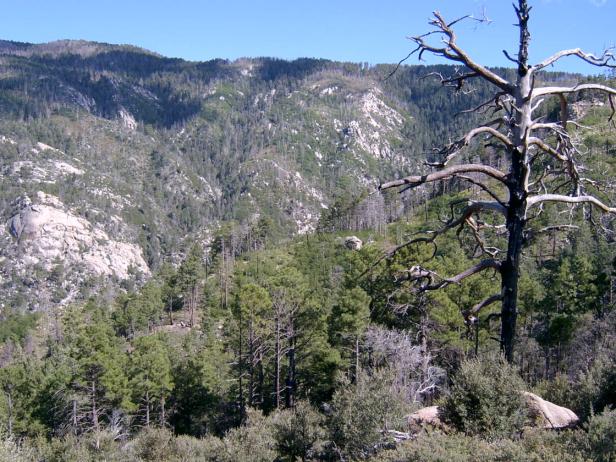
Photo Point 100, looking SE to Mt. Lemmon across the head of Canada del Oro, as seen from Samaniego Ridge, near Shovel Springs, 7600 ft, September 2008. The foreground is dominated by post-burn Ceanothus fendleri and silverleaf oak, 1 and 2m tall respectively. The midground forest is Ponderosa and SW white pine mixed with Douglas fir. A similar pattern persists on the far slope facing the camera, with pine/fir in the mesic draws, and oak/Ceanothus on the ridges.
Desired Conditions
Desired conditions are adapted from Ponderosa pine-evergreen shrub, mid-scale in March 2010 Coronado National Forest planning documents.
At the mid-scale, the ponderosa pine-evergreen shrub is characterized by variation in the size and number of tree groups depending on elevation, soil type, aspect, and site productivity. The more biologically productive sites contain more trees per group and more groups per area. Tree density within forested areas generally ranges from 20 to 80 square foot basal area per acre. Openings typically range from 10 percent in the more productive sites to 70 percent in the less productive sites. The mosaic of tree groups comprises a mix of even-aged and uneven-aged patches with all age classes and structural stages present. The mix of natural disturbances sustains the overall age and structural distribution.
Fires are of low- to mixed-severity, burning on the forest floor as well as in the overstory. Crown fires occur in small patches.
Forest structure in the wildland urban interface (WUI ) has smaller, more widely spaced groups of trees than in the non-WUI. There are no stand-replacement fires in the WUI. As ignitions occur, flame lengths will typically be less than four feet. Forest stands are able to withstand and recover from periodic naturally occurring or unwanted, human-initiated wildland fires.
Forest conditions in goshawk post-fledging family areas (PFAs) are similar to general forest conditions except that these forests contain 10 to 20 percent higher basal area in the mid-age to old tree groups than goshawk foraging areas and the remainder of the forest. Goshawk nest areas have forest conditions that are multi-aged but are dominated by large trees with relatively dense canopies.
Historic Mean Fire Return Interval (Schussman et al. 2006 literature review)
2-17 years for ponderosa pine
Primary treatment options (estimated representative project size range):
- Wildland Fire: Prescribed fire and/or wildfire to maintain openings, reduce ground fuels, and site prep (1,000 to 30,000 acres per project)
- Fuelwood sales (targeting ‘invasive’ tree species to protect high value trees) to reduce fuel loading (up to 300 acres per project)
- Thinning around developments for safety-related fuel reduction (up to 500 acres per project)
Secondary treatment options (estimated representative project size range):
- First-entry mechanical treatments to prepare for fire reintroduction (mastication/crushing, pushing, thinning) (up to 2,500 acres per project)
- Herbicide and mechanical treatment for exotics (to maintain openings) (up to 1,000 acres per project)
- Grazing to reduce fuel loading
- Fuel break construction to aid in fire management
Other Vegetation classifications:
Ecological System as defined by the Southwest Regional Gap Analysis Project
Biome after Brown, Lowe and Pase (1979)
Mid-scale Dominance Type (USFS Coronado NF GIS)
Community after Whittaker and Niering (1975)
Pine-oak woodland