Desert-oak transition on hills and mountains derived primarily from sedimentary and volcanic rocks
This EU is almost exclusively in the Little Rincons, between 3300 and 5000 feet, alongside Paige Creek. It differs from the “Desert-oak transition on granitics” EU in the following ways: less steep (0% cliffs vs. 7%), fewer dry steep slopes (38% vs. 55%), and a stronger influence of the Chihuahuan desert.
The lithology is mostly heavily metamorphosed tectonites derived from Devonian, Cambrian and Precambrian sedimentary rocks. Added to the mix are schist, marble, granite, and limestone.
The vegetation is similarly complex, but can summarized as desert grassland on steep hills. In the photo below, looking south towards Eagle Peak in the Little Rincons, the foreground is primarily beargrass, whitethorn, mariola, and banana yucca on crumbling granite. Just upslope, on quartzite, there are mesquite and juniper. Higher yet, on a 5000 foot north-facing limestone slope, there are scattered juniper and oaks with under 30% cover, which is less common then they would be in the “Desert-oak transition on granitics” EU.
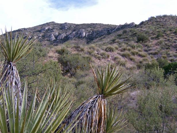
Photo Point 59. Little Rincons, 4000 feet, near Paige Creek, looking SE to Eagle Peak, Sept 2007.
Behind the camera station, saguaros appear on warm slopes just above Paige Creek, but the big cactus is relatively rare in this mostly Chihuahuan ecological unit. The exception is ELT 132a, which lies at the mouth of Canada del Oro, on the NE side of the Catalinas (see below) Here, just east of the Biosphere, saguaros and blue palo verde are common on south slopes, while junipers favor north slopes. Grasses are abundant. The ELT is included in this EU because of its bedrock geology (it is not primarily granitics), topography, and because it lacks the rosewood and hopbush so common in “desert-oak transition on granitics.”
This EU is poorly known. It was visited briefly, along its periphery, on two occasions. Otherwise, it’s been a matter of looking in with binoculars from afar.
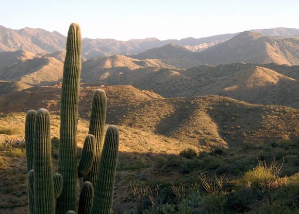
Photo Point 239. Catalinas, near Biosphere, about 3.5 miles SW of Oracle, overlooking Copper Hills wash at about 3900 feet. October, 2008. Mt. Lemmon is the high point in right background.
Desired Conditions
Desired conditions are adapted from Semi-desert grassland, mid-scale desired condition statements in March 2010 Coronado National Forest planning documents.
Fires occur every 2.5 to 10 years. Native species are present. Plant basal cover is between 5-15%; plant litter 25-55%; canopy cover 25-65% for perennial grasses, 1-10% for forbs, and 5-15% for shrubs and succulents; tree canopy cover is 0 to 2%.
Historic Mean Fire Return Interval (Schussman et al. 2006)
2.5-10 years for semi-desert grassland
Primary treatment options (representative project size range):
- Prescribed fire and/or wildfire to maintain openings, reduce ground fuels, and site prep (1,000 to 30,000 acres per project)
Supplemental treatment options (representative historic project size range):
- First-entry mechanical treatments to prepare for fire reintroduction (mastication/crushing, pushing, thinning) (up to 2,500 acres per project)
- Thinning around developments for safety-related fuel reduction (up to 500 acres per project)
- Cut and scatter brush along trails (up to 500 acres per project)
- Herbicide and mechanical treatment for exotics and shrub management (to maintain
- openings) (up to 1,000 acres per project)
- Fuelwood sales (smaller diameter, including aspens) to reduce fuel loading (up to 300 acres per project)
Other considerations:
May be wilderness considerations with treatments