Upper Sonoran desert on pediments derived from granite, gneiss, and similar rocks
This pediment is found largely on the granite and granodiorite bedrock pediment at the base of the Rincon Mountains in the Rincon valley, and along the foot of Samaniego Ridge on the NE slope of the Catalinas. Soils are shallow and support a tree/shrub mix of whitethorn, palo verde, and mesquite, typically 2m to3m tall and combining for 10-24% cover. Grasses are sparse, typically less than 5 %, and favoring annuals. Prickly pear and fairy duster are common associates, often combining for another 5-9 % cover. Burro weed, Isocoma tenuisecta, can be common in the Rincon Valley, but not dominant.
The land is flat or rolling hills; only 16% has slopes greater than 18%. The steeper parts are host to saguaros and palo verde, and on the warmest exposures, the tree/shrub called samota (see Photo Point 32, below). Mesquite is not much evident in the photos below, but it can be co-dominant or dominant, usually no more than 3 m tall, and with no more than 10-24% cover. An exception is at the toe of Samaniego ridge, where mesquite (with scattered blue/emory oak) can give 25-39% cover.
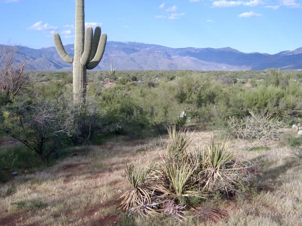
Photo Point 50, Rincon Valley, as seen from Old Spanish Trail near the X-9 ranch road, 3300 feet, September 2007. Foothill paloverde (3 m) and white thorn (2.5m) are co-dominant, combining for 20-30% cover. Fairyduster, catclaw, banana yucca, and prickly pear are common associates, each with 1-4% cover. Saguaro and ocotillo are uncommon except close to the mountain front. Abundant annuals include needle grama (in photo) and purple aster. Creosote is often absent, but can be locally common. Mesquite is mostly restricted to watercourses, a minor element in the flora until close to the mountain. In the foothills near Colossal Cave, for example, mesquite is codominant or dominant.
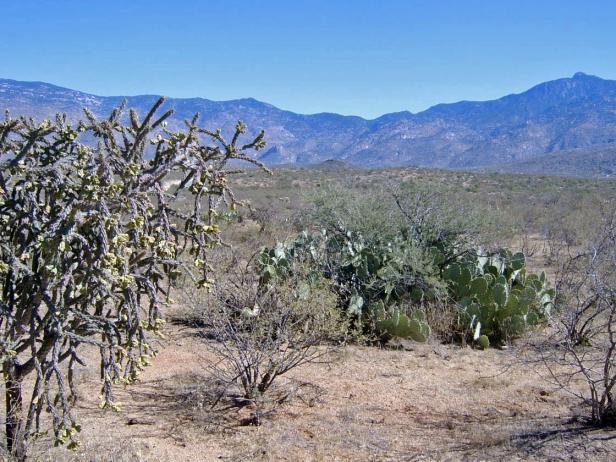
Photo Point 196, Rincon Valley, along X-9 Ranch Road, about 2.5 miles NE of Old Spanish Trail, 3300 feet, October 2008. The big change from photo point above (PP 50) is the decline of palo verde (less than 1% cover) and the clear dominance of whitethorn, with 15-24 cover. The most common associates are prickly pear (5-9%) and catclaw (1-4%). Grasses, mainly fluffgrass, are uncommon, while burro weed is common. Saguaros are uncommon.
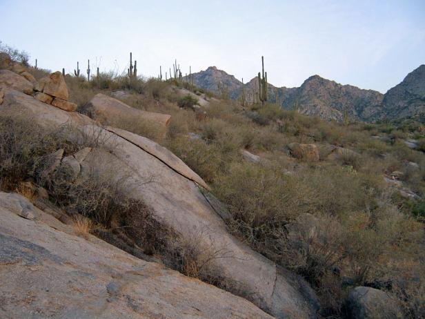
Photo Point 32, NE side of the Catalinas, with Samaniego Ridge in background, 3170 feet, May, 2008. The dominant plant is the shrub/tree Coursetia glandulosa, or samota, about 2 meters tall and with 10-14% cover. Limber bush, fairy duster, and mesquite are common associates, each with 1-4% cover. The grasses, mostly tanglehead, gave another 1-4%. Where this EU is flatter, just upslope, mesquite are more common than samota, which favors the rocks.
Desired Conditions
Desired conditions are adapted from Desert, mid-scale desired condition statements in March 2010 Coronado National Forest planning documents.
On moderately steep hillsides and fan piedmont where alkaline soils are formed in alluvium from mixed parent materials, the predominant species are foothill paloverde, saguaro, prickly pear, cholla, barrel cactus, ocotillo, false mesquite, triangleleaf bursage, bush muhly, slender grama, curly mesquite, spidergrass, tangelhead, purple threeawn, janusia, ayenia and globe mallow. Annual forbs and grasses, an important part of this plant community, fluctuate with precipitation from nearly nothing in dry years to several hundred pounds per acre in wet years. Plant basal cover ranges from 1 to 3 percent, and cover by plant litter ranges from 10 to 75 percent. Canopy cover ranges from 1 to 20 percent for grasses, 1 to 15 percent for forbs, and 5 to 20 percent for shrubs and succulents. Tree canopy cover is 1 to 10 percent.
On moderately steep hillsides and fan piedmont where non-alkaline soils are formed in alluvium from mixed parent materials, the predominant species are foothill paloverde, saguaro, prickly pear, cholla, ocotillo, whitethorn acacia, creosote bush, false mesquite, range ratany, desert zinnia, bush muhly, black grama, slim tridens, fluff grass, janusia, desert senna, and twinberry. Annual forbs and grasses, an important part of this plant community, fluctuate with precipitation from nearly nothing in dry years to several hundred pounds per acre in wet years. Plant basal cover ranges from 1 to 3 percent, and cover by plant litter ranges from 5 to 45 percent. Canopy cover ranges from 1 to 10 percent for grasses, 1 to 10 percent for forbs, and 5 to 20 percent for shrubs and succulents. Tree canopy cover is 1 to 10 percent.
On nearly level floodplains, low stream terraces and canyon bottoms where soils are formed in recent alluvium from mixed parent materials, the predominant species are foothill and blue paloverde, mesquite, catclaw acacia, desert willow, desert hackberry, wolfberry, big bursage, burrobrush, desert honeysuckle, bush muhly, sand and spike dropseed, sideoats grama, tanglehead, spidergrass, and mesa threeawn. Annual forbs and grasses fluctuate with precipitation from nearly nothing in dry years to several hundred pounds per acre in wet years. Plant basal cover ranges from 2 to 5 percent, and cover by plant litter ranges from 5 to 45 percent. Canopy cover ranges from 10 to 20 percent for grasses, 1 to 15 percent for forbs, and 5 to 15 percent for shrubs and succulents. Tree canopy cover is 10 to 15 percent.
Historic Mean Fire Return Interval (Schussman et al. 2006 literature review)
> 250 years for warm desert communities
Primary treatment options (estimated representative project size range):
- Mechanical treatments for fuel reduction and to maintain openings (up to 2,500 acres per project)
- Herbicide treatment for exotics and shrub management to maintain openings and reduce fire spread (up to 1,000 acres per project)
Supplemental treatment option (estimated representative project size range):
- Thinning around developments for safety-related fuel reduction (up to 500 acres per project)
Other Vegetation Classifications: