Ponderosa pine forest on hills and mountains derived from granite, gneiss, and similar rocks
Evenly split between the Rincons and Catalinas, this typically ‘open’ forest occupies drier sites between 7000 and 8700 feet. About 22% of the acreage is relatively flat (at least for a mountain) with slopes less than 18%; in contrast, only about 6% of the mixed conifer forest has slopes less than 18%. Open meadows, small but persistent, occur in both ranges, typically on flats but also on slopes.
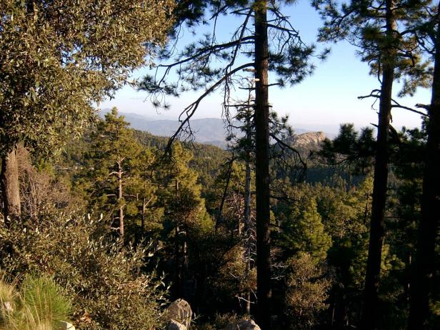
View from Catalina Highway, MP 18, looking SE towards Lizard Rock, Oct 2008. Conifers are mostly Ponderosa pine. Doug fir is common, but less than 5% cover. Silverleaf oak (left foreground) is co-dominant with Ponderosa on steeper slopes.
In both mountain ranges the driest slopes are a mix of Ponderosa and SW white pine, and silverleaf oak. In the Catalinas, the most mesic slopes and ravines hold Douglas Fir, which is curiously absent from most or perhaps all of this EU in the Rincons — no Doug fir were noted on a 2008 hiking loop from Spud Rock to Mica Mountain, Mica Meadow, and Mica Secondary.
In the Catalinas this EU includes ELT 189a, reaching from upper Willow Canyon westward to Rose Canyon, Organization Ridge Road, and Spencer Canyon — the vast basin of Ponderosa pine forest seen by most visitors from the highway. ELT 189b includes the town of Summerhaven and upper Sabino Canyon from Turkey Run Road down to a point roughly a half-mile south of Marshall Gulch, at the USGS gauging station. ELT 125c is a small unit on the south-facing slope of Marshall Peak, and the most xeric of the bunch, with 65% of its slopes classified as dry or very dry; it also holds extensive stands of aspen, along the Aspen Trail.
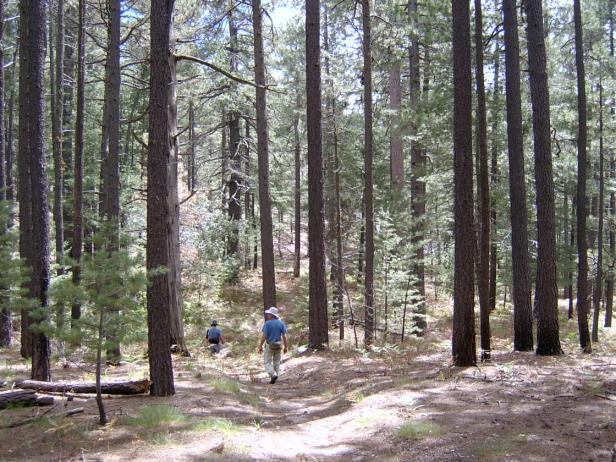
Rincon Mts., September 2008, along the trail between Spud Rock and Mica Meadow. Trees are Ponderosa and SW white pine, with box elder along drainage. Ground cover is needle duff and 1-4% cover of June grass, Koeleria macrantha.
In the Rincons, the EU is a single 3000-acre unit that includes the summit platform between Mica Mountain and Reef Rock, and the area west to Manning Camp and almost down to Cowhead Saddle. Aspen is uncommon. The lowest elevations of this EU include about 500 acres of pine-oak woodland and rocky areas with manzanita and pinyon, with the Ponderosa restricted to north slopes and drainages.
Desired Conditions
Desired conditions are adapted from Ponderosa pine-evergreen shrub, mid-scale desired condition statements in March 2010 Coronado National Forest planning documents.
At the mid-scale, the ponderosa pine-evergreen shrub is characterized by variation in the size and number of tree groups depending on elevation, soil type, aspect, and site productivity. The more biologically productive sites contain more trees per group and more groups per area. Tree density within forested areas generally ranges from 20 to 80 square foot basal area per acre. Openings typically range from 10 percent in the more productive sites to 70 percent in the less productive sites.
The mosaic of tree groups comprises a mix of even-aged and uneven-aged patches with all age classes and structural stages present. The mix of natural disturbances sustains the overall age and structural distribution. Fires are of low- to mixed-severity, burning on the forest floor as well as in the overstory. Crown fires occur in small patches.
Forest structure in the wildland urban interface (WUI) has smaller, more widely spaced groups of trees than in the non-WUI. There are no stand-replacement fires in the WUI. As ignitions occur, flame lengths will typically be less than four feet. Forest stands are able to withstand and recover from periodic naturally occurring or unwanted, human-initiated wildland fires.
Forest conditions in goshawk post-fledging family areas (PFAs) are similar to general forest conditions except that these forests contain 10 to 20 percent higher basal area in the mid-age to old tree groups than goshawk foraging areas and the remainder of the forest. Goshawk nest areas have forest conditions that are multi-aged but are dominated by large trees with relatively dense canopies.
Historic Mean Fire Return Interval (Schussman et al. 2006 literature review)
2-17 years for ponderosa pine
Primary treatment options (estimated representative project size range)
- Wildland fire: Prescribed fire and/or wildfire to maintain openings, reduce ground fuels, and site prep (1,000 to 30,000 acres per project)
- Thinning for forest product industry to reduce fuel loading and around developments for safety-related fuel reduction (up to 500 acres per project)
Supplemental treatment options (estimated representative project size range)
- First-entry mechanical treatments to prepare for fire reintroduction (mastication/crushing) (up to 2,500 acres per project)
- Fuelwood sales (smaller diameter, including aspens) to reduce fuel loading (up to 300 acres per project)
Other possible treatments in type
- Seeding
- Reforestation planting
- Burning and thinning to maintain meadows
Other Vegetation Classifications