Mixed conifer forest on mountains derived mostly from metasedimentary rocks
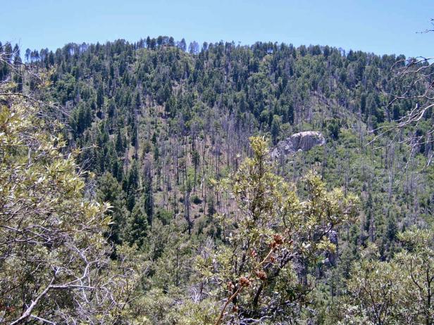
View north of the west-facing slope along the trail from Lemmon Meadow to Samaniego Ridge, 9000 feet, September 2008. ELT 125a.
Found along the summit of Santa Catalina Mountains from Mt. Bigelow to Mt. Lemmon, this forest ranges from 7,500 to the summit at 9157 feet. About 68% of this EU is north-facing and over 18% slope, dominated by Douglas fir, white fir, and SW white pine. South-facing slopes and flats, make up the remaining 32% of the unit, and include areas of primarily Ponderosa/SW white pine with silverleaf oak. Many of these drier stands burned during the 2003 Aspen, including the southern aspects of Marshall Gulch, Carter Canyon, and Upper Sabino Canyon along the highway from Summerhaven to Ski Valley, as well as the slopes below Sykes Knob and Inspiration Rock.
The unit is divided among three ELTs, based on differences in geology and landform. ELT 125c is on a very steep north-facing slope from Mt. Bigelow to Soldier Camp — the entire unit is at least an 18% slope, and one-third exceeds a 70% slope. Along the Butterfly Trail from Soldier Camp (see photo below) there is nearly a mile of forest without pines — only Douglas and white fir, gambel oak, and maple, with Jamesia americana a common shrub in a sparse understory.
Looking south from Butterfly peak, to summit ridge near Soldier Camp, showing Douglas and white fir in ELT125c at 8000 feet, on June 2009.
ELTs 125a and 125b include gentler slopes, and in all aspects. North-facing slopes and drainages such as Bear Wallow (ELT 125b) and Marshall Gulch (125a) are primarily Douglas and white fir, and known for the autumn colors of bigtooth maple. ELT125a includes the summit of Mt. Lemmon, where a stand of corkbar fir grows among species like box elder, Rocky Mountain maple, Arizona mountain ash (Sorbus dumosa ) and orange gooseberry (Ribes pinetorum). Aspen is locally common, in groves of 10-15 m trees.
Summerhaven proper, along Upper Sabino, is not part of this ecological unit, but instead in 189b, in the Ponderosa Pine EU.
Desired Conditions
Desired conditions are adapted from Wet mixed conifer, mid-scale desired condition statements in March 2010 Coronado National Forest planning documents.
At the mid-scale, the size and number of groups and patches vary depending on disturbance, elevation, soil type, aspect, and site productivity. Patch sizes vary but are frequently in the hundreds of acres and occasionally in the thousands of acres. Groups and patches of tens of acres or less are relatively common. A mosaic of primarily even-aged groups and patches, which vary in size, species composition, and age, is present. Grass, forb, and shrub openings created by disturbance may comprise 10 to 100 percent of the mid-scale area depending on the disturbance type and scale. Aspen is occasionally present in large patches.
Density ranges from 20 to 110 square foot basal area per acre depending upon disturbance and seral stages of groups and patches. Coarse woody debris, including downed logs, varies by seral stage, with averages ranging from 5 to 20 tons per acre for early-seral stages; 20 to 40 tons per acre for mid-seral stages; and 80 tons per acre or greater for late-seral stages.
Mixed- (Fire Regime III) and high-severity (Fire Regime IV) fires and other disturbances maintain desired overall tree density, structure, species composition, coarse woody debris, and nutrient cycling. High-severity fires generally do not exceed 1000 acre patches of mortality. Other smaller disturbances occur more frequently. Forests in the wildland urban interface (WUI) are dominated by early-seral fire-adapted species growing in an overall more open condition than the remainder of the forest. These conditions result in fires that burn primarily on the forest floor and rarely spread as crown fire.
Forest conditions in goshawk post-fledging family areas (PFAs) are similar to general forest conditions except that these forests contain 10 to 20 percent higher basal area than goshawk foraging areas and the general forest. Nest areas have forest conditions that are multi-aged but are dominated by large trees with relatively dense canopies.
Historic Mean Fire Return Interval (Schussman et al. 2006 literature review)
10-22 years for mixed conifer forest
Primary treatment options (estimated representative project size range):
- Wildland fire: Prescribed fire and wildfire to maintain openings, reduce ground fuels, and site prep (1,000 to 30,000 acres per project)
- Fuelwood sales (smaller diameter, including aspens) to reduce fuel loading (up to 300 acres per project)
- Thinning for forest product industry to reduce fuel loading (up to 500 acres per project)
Supplemental treatment options (estimated representative project size range):
- Mechanical treatments for exotics and shrub management to maintain openings and mastication/crushing to reduce ladder and ground fuels (up to 2,500 acres per project)
- Herbicide treatment for exotics (cheatgrass) and shrub management to maintain openings (up to 1,000 acres per project)
- Open corkbark fir areas for regeneration (cutting/seedbed prep, including burning
- Reforestation to local specs (not for final densities)