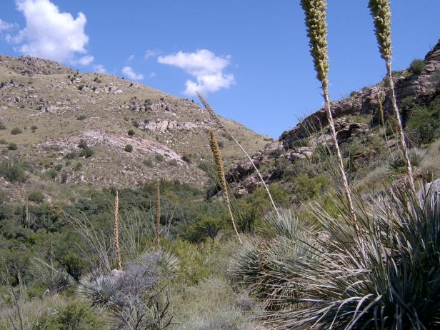
Desert-oak transition on mountains derived from granite, gneiss, and similar rocks
Ranging from 2700 ft (835m) to 6200 feet (2000m), with a mean elevation of 4200 feet (1360m), this large unit occurs mostly on the southern and northwestern fronts of the Catalinas and Rincons. Here the mountains rise steeply (only 15% of the unit is less than 18% slope) and the transition from Sonoran desert to oak woodland is strongly influenced by aspect. The southern exposures typically hold saguaro, while the northern exposures harbor blue oak and rosewood. Although the trees rarely exceed 10% cover on the cooler aspects, the total shrub stratum can exceed 40% cover, with the most common species being catclaw, sotol, hopbush, and oraganillo. Desert cotton and grasses are also abundant. Buffelgrass, increasingly common at lower elevations, is currently uncommon at the locations visited in this unit.
This unit stretches over 40 miles, with significant differences at its extremes. In general, the front range of the Catalinas and the south side of Rincon Peak hold more desert species — saguaro and palo verde — while the northwest-facing slope of the Catalinas and Rincons hold more oak, rosewood. Mesquite grassland can occur anywhere there are deeper soils, which is typically along canyon bottom terraces but can also occur on slopes.

Molino Canyon, Catalinas, 4000 feet. Near MP 4 on the Catalina Highway, looking NNW to a SSE-facing slope that is largely lovegrass, fairy duster, catclaw, mesquite, shindagger, and scattered blue oak. The cooler foreground slope is dominated by organillo, with associated sotol and hopbush and abundant grasses: lovegrass, bush muhly, spidergrass, and sideoats. Other common species include catclaw, blue oak, rosewood, and turpentine bush.

Photo Point 214. Romero Canyon, Catalinas, 4000 feet, looking NW. The light green shrub is hopbush, with 15-24% cover, and mostly a cohort of 1.6 m height. It also grows up the SE facing slope in the back right. The darker trees at center are mostly blue oak tracing the stream bed, bordered by low-growing fairy duster and abundant (10-14% cover) grasses including plains lovegrass, tanglehead, bull grass, cane beardgrass, and hairy grama. Other common associates include scattered white and Emory oak, sotol, and wait-a-minute bush.
Desired Conditions
Desired conditions are adapted from Semi-desert grassland, mid-scale desired condition statements in March 2010 Coronado National Forest planning documents.
Fires occur every 2.5 to 10 years. Native species are present. Plant basal cover is between 5-15%; plant litter 25-55%; canopy cover 25-65% for perennial grasses, 1-10% for forbs, and 5-15% for shrubs and succulents; tree canopy cover is 0 to 2%.
Historic Mean Fire Return Interval (Schussman et al. 2006)
2.5-10 years for semi-desert grassland
Primary treatment options (representative project size range):
- Prescribed fire and/or wildfire to maintain openings, reduce ground fuels, and site prep (1,000 to 30,000 acres per project)
Supplemental treatment options (representative historic project size range):
- First-entry mechanical treatments to prepare for fire reintroduction (mastication/crushing, pushing, thinning) (up to 2,500 acres per project)
- Thinning around developments for safety-related fuel reduction (up to 500 acres per project)
- Cut and scatter brush along trails (up to 500 acres per project)
- Herbicide and mechanical treatment for exotics and shrub management (to maintain
- openings) (up to 1,000 acres per project)
- Fuelwood sales (smaller diameter, including aspens) to reduce fuel loading (up to 300 acres per project)
Other considerations:
May be wilderness considerations with treatments
Other vegetation classification:
Ecological System as defined by the Southwest Regional Gap Analysis Project
Biome after Brown, Lowe and Pase (1979)
Mid-scale Dominance Type (USFS Coronado NF GIS)
Community after Whittaker and Niering (1975)
