Mountain mahogany on hills and mountains derived from limestone, marble, and assoicated rocks
This small EU is immediately apparent by the pale strata of limestone and the change in vegetation, as pictured below on Marble Peak in the Santa Catalinas.
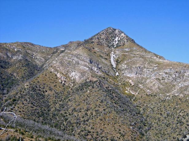
The SE facing slope of Marble Peak, October 2008. Summit is 7600 ft.
This EU is characterized by steep bands of limestone (about 19% of the land exceeds a slope of 70%) holding a community of the dominant species, 2m tall mountain mahogany, along with snakeweed, and sotol. Total cover of these species is around 40-50%, and is accompanied by an additional 10% cover of the annual grass Aristida adscensionis.
Although manzanita is not present, mountain mahogany (Cercocarpus montanus) is fire-adapted, and it’s fair to describe the vegetation as a kind of chaparral. According to the USFS mid-scale vegetation map, 39% of this EU is sparsely vegetated. Excluding the cliffs, this ‘sparse’ area is that which burned during the Aspen Fire, on the NW side of Marble Peak.
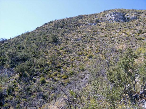
October 2008, east-facing slope of Marble Peak, showing contact between the mountain mahogany/snakeweed/sotol community on limestone (back right and foreground right), and the meta-sedimentary rocks (left) with juniper, Emory oak, and silktassel.
The EU boundary was drawn with the aid of a geologic map, but the vegetation seems to have chosen their own bounds: about 200 acres of the SW corner of the EU is actually more similar to the adjoining oak woodland EU (part of LTA 157), with emory oak, alligator juniper, and silktassel (Garrya). Note, too, that the summit of Marble Peak is also juniper and oak.
Although the acreage of mountain mahogany chaparral is likely overestimated on Marble Peak, it is also present on those lands that fall under the EU labeled “Oak/pinyon/juniper woodland and grassland on mountains influenced by limestone and associated rocks.” However, the mountain mahogany habitat is fragmented by the complicated bedrock geology, as can be seen in the vicinity of Peppersauce Canyon (LTA 190).
Desired Conditions
Desired conditions are adapted from Interior chaparral, landscape- and fine-scale desired condition statements in March 2010 Coronado National Forest planning documents.
Landscape Scale (10,000+ acres)
The interior chaparral varies from widely scattered pockets within grasslands and woodlands to more extensive areas on steep mountain slopes. Species composition and dominance varies across the broad range of soils and topography, but are dominated by shrubs including one or some of the following: shrub live oak, birchleaf mountain mahogany, pointleaf manzanita, desert ceanothus, pringle manzanita, yellow leaf silktassel, Arizona oak, and Emory oak. The canopy is nearly closed in about 90 percent of the community. Where it is more open, there is a grass and forb component including native species found in the adjacent grassland and woodland communities. Ground cover consists primarily of shrub litter covering 35 percent to 45 percent of the soil surface. Fire regimes are a natural dynamic that provide landscape diversity, wildlife habitat, and soil stability, and maintain a variety of densities and age classes. Fire occurs at intervals of 20 to 100 years, and is usually stand replacing.
Fine Scale (10 acres or less)
Soil condition indicators of 35 to 45 percent of total ground cover by litter and plant basal area and no signs of compaction or accelerated erosion signify that soil function is being sustained and soil is functioning properly and normally. The ability of soil to maintain resource values and sustain outputs is high.
Vegetation structure in chaparral stands immediately adjacent to high risk components of the wildland urban interface (WUI) has an arrangement that is horizontal and close to the ground. Typical fire behavior is dramatically reduced as a result of the rearrangement of the natural fuel profile.
WUI areas include those of resident human populations at imminent risk from wildland fire. These areas may also include critical communications sites, municipal watersheds, high voltage transmission lines, observatories, church camps, scout camps, research facilities, and other structures that if destroyed by fire would result in hardship to communities. These areas encompass not only the sites themselves, but also the continuous slopes and fuels that lead directly to the sites, regardless of the distance involved.
Historic Mean Fire Return Interval (Schussman et al. 2006 literature review)
20-200 years for interior chaparral
Primary treatment option (estimated representative project size range):
- Wildland fire: Prescribed fire and/or wildfire to maintain openings, reduce ground fuels, and site prep (1,000 to 30,000 acres per project)
Supplemental treatment option (estimated representative project size range):
- Thinning to prepare for fire reintroduction in WUI areas (up to 500 acres per project)
Other Vegetation Classifications: