Mixed conifer forest on mountains derived from granite, gneiss, and similar rocks
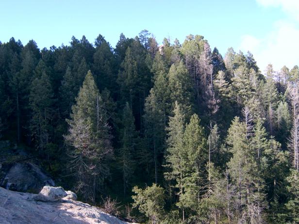
View SW, about 1/4 mile west of Italian Springs, elevation 8000 ft, along North Slope Trail, September 2008
Found only on the north slope of the Rincon Mountains, this Douglas fir/white fir and pine forest ranges from 6,500 to the summit at 8,666 feet. Most of this EU — 87% — is cool slopes and shallow valleys of over 18% slope, and dominated by Douglas fir, white fir, and white pine. Canopy cover can be dense, often over 75%, with heavy litter. Openings in the canopy allow an understory of snowberry, New Mexico raspberry, and Holodiscus. Drier ridgelines are a mix of Ponderosa pine, white pine, Gambels oak, and Douglas fir. Similar habitat is at the edges of the unit, including the summit of Mica Mountain and Spud Rock, where the dense mixed-conifer transitions to open stands of Ponderosa and white pine. Aspen is rare, with only a few small populations scattered near Italian Springs.
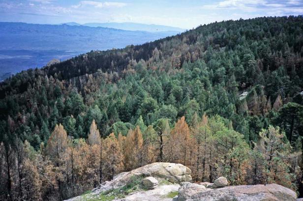
View NE from Spud Rock, September, 2006. Elevation 8500 ft.
The Coronado NF Mid-scale map characterizes this unit as 99% trees with at least 30% cover. However, as can be seen in this view NE from Spud Rock, many of these trees were killed by the 2003 Helen Fire, yet retained their needles. Judging from aerial photos, at least a third of the unit was mortally burned. Another 10% of the unit is rock domes, some large enough to form natural barriers to fire. In September of 2008, the burned areas were dominated by the grass Bromus ciliatus and a 0.8m tall composite, Laennecia (Conyza) schiedeana, known as pine horseweed. New Mexico locust was present but with only 1-4% cover.
A similar mixed-conifer ecological unit in the Santa Catalinas is mostly restricted to metasediments like quartzite and schist, which make up the high elevation north slope. The Rincon unit differs in at least three ways. (1) It lacks corkbark fir; (2) there are no significant stands of aspen or maple; and (3) it is entirely in NPS wilderness, with no road access within four miles.
Desired Conditions
Desired conditions are adapted from Wet mixed conifer, mid-scale desired condition statements in March 2010 Coronado National Forest planning documents.
At the mid-scale, the size and number of groups and patches vary depending on disturbance, elevation, soil type, aspect, and site productivity. Patch sizes vary but are frequently in the hundreds of acres and occasionally in the thousands of acres. Groups and patches of tens of acres or less are relatively common. A mosaic of primarily even-aged groups and patches, which vary in size, species composition, and age, is present. Grass, forb, and shrub openings created by disturbance may comprise 10 to 100 percent of the mid-scale area depending on the disturbance type and scale. Aspen is occasionally present in large patches.
Density ranges from 20 to 110 square foot basal area per acre depending upon disturbance and seral stages of groups and patches. Coarse woody debris, including downed logs, varies by seral stage, with averages ranging from 5 to 20 tons per acre for early-seral stages; 20 to 40 tons per acre for mid-seral stages; and 80 tons per acre or greater for late-seral stages.
Mixed- (Fire Regime III) and high-severity (Fire Regime IV) fires and other disturbances maintain desired overall tree density, structure, species composition, coarse woody debris, and nutrient cycling. High-severity fires generally do not exceed 1000 acre patches of mortality. Other smaller disturbances occur more frequently. Forests in the wildland urban interface (WUI) are dominated by early-seral fire-adapted species growing in an overall more open condition than the remainder of the forest. These conditions result in fires that burn primarily on the forest floor and rarely spread as crown fire.
Forest conditions in goshawk post-fledging family areas (PFAs) are similar to general forest conditions except that these forests contain 10 to 20 percent higher basal area than goshawk foraging areas and the general forest. Nest areas have forest conditions that are multi-aged but are dominated by large trees with relatively dense canopies.
Historic Mean Fire Return Interval (Schussman et al. 2006 literature review)
10-22 years for mixed conifer forest
Primary treatment options (estimated representative project size range):
- Wildland fire: Prescribed fire and wildfire to maintain openings, reduce ground fuels, and site prep (1,000 to 30,000 acres per project)
- Fuelwood sales (smaller diameter, including aspens) to reduce fuel loading (up to 300 acres per project)
- Thinning for forest product industry to reduce fuel loading (up to 500 acres per project)
Supplemental treatment options (estimated representative project size range):
- Mechanical treatments for exotics and shrub management to maintain openings and mastication/crushing to reduce ladder and ground fuels (up to 2,500 acres per project)
- Herbicide treatment for exotics (cheatgrass) and shrub management to maintain openings (up to 1,000 acres per project)
- Open corkbark fir areas for regeneration (cutting/seedbed prep, including burning
- Reforestation to local specs (not for final densities)
Other Vegetation Classifications: