Mesquite grasslands on pediments influenced by granite or granite-like rocks
At the northern end of the Catalinas, the town of Oracle is bordered by mesquite grasslands growing on a veneer of decomposed granite over bedrock. Elevations are high for mesquite (1150-1500 m, or 3700-5200 ft., which might explain why the mesquite are fairly large (2.5 to 4 m average), the grasses abundant (over 10% cover), and catclaw is a common associate. The land is flat: only 8% of the EU has a slope greater than 18%.

Photo Point 182, Catalinas, about 3 miles SE of Oracle, 4300 ft., October, 2008. Turpentine bush in flower catches the eye, but the mesquite and catclaw dominate the thin soils of this pediment, each with 10-14% cover. The mesquite average 4 m tall, and the catclaw, 1.5 m tall. Next in abundance are wait-a-minute bush, fairy duster, and sotal. Total grass cover exceeds 10%, and includes desert species like bush muhly, and mountain species like bull grass.
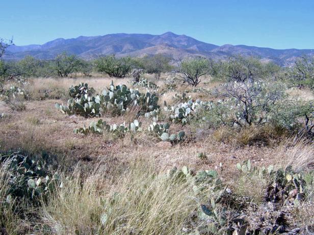
Photo Point 223, Catalinas, 3 miles west of Oracle, at 4500 feet, October, 2008. Prickly pear and mesquite are the dominants, each with 10-14% cover. Cane cholla and catclaw are common associates. Spider grass, plains lovegrass, tobosa grass, and bristle grass are common.
Desired Conditions
Desired conditions are adapted from Semi-desert grassland, mid-scale desired condition statements in March 2010 Coronado National Forest planning documents. This description does not include the desired conditions for steep hillslopes. It focuses instead on the moderately sloping and level areas because this Ecological Unit contains little steep terrain.
On moderately sloping pediments where soils have formed in place on acid igneous and metamorphic parent materials like granite, gneiss, schist and rhyolite, the potential native plant community is dominated by perennial grasses and sub-shrubs with lesser amounts of large shrubs and succulents. The predominant species are black, sideoats, slender, sprucetop, Santa Rita and hairy gramas, tanglehead, Arizona muhly, curly mesquite, ocotillo, false mesquite, range and spreading ratany, shrubby buckwheat, dalea, agave, mimosa species, wire lettuce, penstemon, trailing four o’clock, spike moss, and shrubby deervetch. Plant basal cover ranges from 6 to 15 percent, and cover by plant litter ranges from 25 to 40 percent. Canopy cover ranges from 20 to 50 percent for perennial grasses, 0 to 3 percent for forbs, and 10 to 25 percent for shrubs and succulents. Tree canopy cover is 0 to 2 percent and may include species like one-seed juniper and mesquite.
On moderately steep hillsides and fan piedmont where soils have formed in loamy alluvium from mixed sources, the plant community is dominated by native perennial grasses and sub-shrubs with lesser amounts of large shrubs and succulents. The predominant species are sideoats, slender, black, sprucetop and hairy gramas, tanglehead, cane beardgrass, plains lovegrass, wolftail, spidergrass, purple threeawn, false mesquite, range ratany, shrubby buckwheat, agave, prickly pear, barrel cactus, banana yucca, globe mallow, bluedicks, and wire lettuces. Plant basal cover ranges from 6 to 15 percent, and cover by plant litter ranges from 10 to 50 percent. Canopy cover ranges from 20 to 60 percent for perennial grasses, 1 to 15 percent for forbs, and 2 to 20 percent for shrubs and succulents. Tree canopy cover is 0 to 1 percent and may include species like one-seed juniper, catclaw acacia and mesquite.
On moderately steep hillsides, fan piedmont, and ballenas where soils have formed in coarse loamy, calcareous alluvium and colluviums, the plant community is dominated by native perennial grasses, shrubs and succulents. The predominant species are sideoats grama, black grama, bush muhly, slim tridens, shortleaf tridens, tanglehead, Hall’s panic, spike pappusgrass, blue threeawn, ocotillo, condalia, mariola, false mesquite, range ratany, feather dalea, Wright’s beebrush, mormon tea, twinberry, desert zinnia, banana yucca, prickly pear, bahia, dogweed, croton, paperflower, and trailing four o’clock. Plant basal cover ranges from 6 to 15 percent, and cover by plant litter ranges from 10 to 50 percent. Canopy cover ranges from 20 to 60 percent for perennial grasses, 1 to 5 percent for forbs, and 5 to 30 percent for shrubs and succulents. Tree canopy cover is 0 to 1 percent and may include species like one-seed juniper and mesquite.
On nearly level floodplains, low stream terraces and canyon bottoms where soils are formed in recent alluvium from mixed parent materials, the plant community is dominated by native trees and shrubs with lesser amounts of perennial grasses, vines, and forbs. The predominant species are mesquite, catclaw acacia, desert willow, blue paloverde, netleaf hackberry, western soapberry, burrobrush, desert honeysuckle, clematis, greythorn, sacaton, bush muhly, sand and spike dropseed, sideoats grama, tanglehead, green sprangletop, plains bristlegrass, spidergrass, mesa threeawn, coyote melon, canaigre, pigweed, morning-glory, ragweed, and wishbone bush. Plant basal cover ranges from 6 to 17 percent, and cover by plant litter ranges from 30 to 75 percent. Canopy cover ranges from 15 to 50 percent for grasses, 1 to 15 percent for forbs, and 2 to 20 percent for shrubs and succulents. Tree canopy cover ranges from 15 to 30 percent.
Fire plays a key role in maintaining the grasslands, with large, low intensity fires usually occurring in the early summer, every 2.5 to 10 years. These fires reduce shrub cover while having little negative effect on grasses. The ability of soil to maintain resource values and sustain outputs is high.
Historic Mean Fire Return Interval (Schussman et al. 2006 literature review)
2.5-10 years for semi-desert grassland
Primary treatment options (estimated representative project size range):
- Wildland fire: Prescribed fire and/or wildfire to maintain openings, reduce ground fuels, and site prep (1,000 to 30,000 acres per project)
- First-entry mechanical treatments to prepare for fire reintroduction (mastication/crushing, pushing, thinning) (up to 2,500 acres per project)
Secondary treatment options (estimated representative project size range):
- Thinning around developments for safety-related fuel reduction and lop and scatter brush along trails (up to 500 acres per project)
- Herbicide and mechanical treatment for exotics and shrub management and to maintain openings (up to 1,000 acres per project)
- Fuelwood sales (smaller diameter, including aspens) to reduce fuel loading (up to 300 acres per project)
Other vegetation classifications:
Ecological System as defined by the Southwest Regional Gap Analysis Project
Biome after Brown, Lowe and Pase (1979)
143.1 Scrub-Grassland (Semidesert Grassland)
Mid-scale Dominance Type (USFS Coronado NF GIS)
Community after Whittaker and Niering (1975)
Desert grassland