Mesquite grasslands and oak savannas on low granitic hills and plains
Between the Rincons and the Catalinas are about 30 square miles of elevated plains and hills between 3600 and 4600 feet. This is Redington Pass. Its vegetation is largely grasslands with mesquite in broad bottoms, and blue, Emory, and Arizona oak on the slopes. Juniper, catclaw, and wait-a-minute are common associates. Saguaros, uncommon, fringe the lowest elevations on warm slopes. Typically, perennial bunchgrasses are the dominant groundcover, except near cattle-tanks where weeds like ragweed can take over. Tree cover is typically 5-20%; shrub cover 10-25%; and grasses 15-40%. Where drainages converge in basins, there are often mesquite and hackberry bosques of 1-10 acres, such as in Italian Flat.
The vegetation and elevations within this EU are much like the desert-oak transition, but with this difference: there is little steep terrain. About 72% of the acreage is under an 18% slope. The scattered steep parts are mostly associated with the single deep canyon in EU, Upper Bullock, The floodplain and riparian galley of Bullock holds impressive sycamore and mesquite.
The bedrock is 99% granitic, with the exception of 200 acres of Paleozoic sediments near Chimney Rock. Granitic outcrops are typically small and would have little effect on spread of fire.
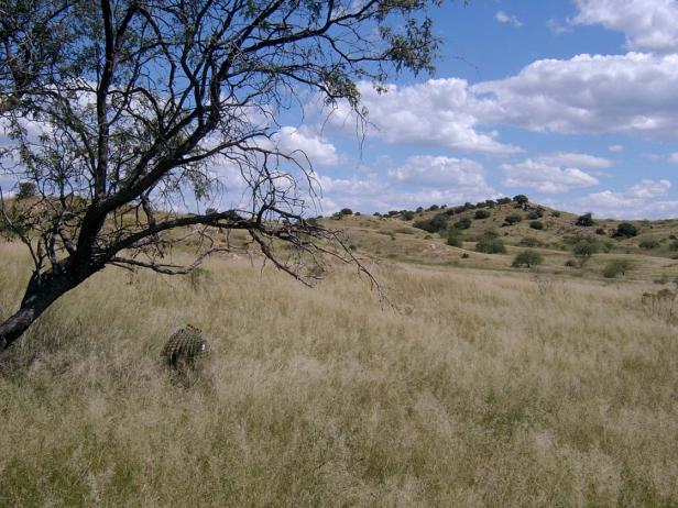
Photo Point 118. Redington Pass, south of main road, just west of turnoff to Bellota Ranch, 4300 feet. Love grass, Viguiera annua, turpentine bush, and mesquite are common in the open field. On the hills beyond, mesquite gives way oaks and juniper and coral bean. Hidden but abundant in the grass is wait-a-minute bush, Mimosa.
Desired Conditions
Desired conditions are adapted from Semi-desert grasslands, mid-scale desired condition statements in March 2010 Coronado National Forest planning documents. This description does not include the desired conditions for steep hillslopes from the Forest planning documents. It focuses instead on the moderately sloping and level areas because this Ecological Unit contains little steep terrain.
On moderately sloping pediments where soils have formed in place on acid igneous and metamorphic parent materials like granite, gneiss, schist and rhyolite, the potential native plant community is dominated by perennial grasses and sub-shrubs with lesser amounts of large shrubs and succulents. The predominant species are black, sideoats, slender, sprucetop, Santa Rita and hairy gramas, tanglehead, Arizona muhly, curly mesquite, ocotillo, false mesquite, range and spreading ratany, shrubby buckwheat, dalea, agave, mimosa species, wire lettuce, penstemon, trailing four o’clock, spike moss, and shrubby deervetch. Plant basal cover ranges from 6 to 15 percent, and cover by plant litter ranges from 25 to 40 percent. Canopy cover ranges from 20 to 50 percent for perennial grasses, 0 to 3 percent for forbs, and 10 to 25 percent for shrubs and succulents. Tree canopy cover is 0 to 2 percent and may include species like one-seed juniper and mesquite.
On moderately steep hillsides and fan piedmont where soils have formed in loamy alluvium from mixed sources, the plant community is dominated by native perennial grasses and sub-shrubs with lesser amounts of large shrubs and succulents. The predominant species are sideoats, slender, black, sprucetop and hairy gramas, tanglehead, cane beardgrass, plains lovegrass, wolftail, spidergrass, purple threeawn, false mesquite, range ratany, shrubby buckwheat, agave, prickly pear, barrel cactus, banana yucca, globe mallow, bluedicks, and wire lettuces. Plant basal cover ranges from 6 to 15 percent, and cover by plant litter ranges from 10 to 50 percent. Canopy cover ranges from 20 to 60 percent for perennial grasses, 1 to 15 percent for forbs, and 2 to 20 percent for shrubs and succulents. Tree canopy cover is 0 to 1 percent and may include species like one-seed juniper, catclaw acacia and mesquite.
On moderately steep hillsides, fan piedmont, and ballenas where soils have formed in coarse loamy, calcareous alluvium and colluviums, the plant community is dominated by native perennial grasses, shrubs and succulents. The predominant species are sideoats grama, black grama, bush muhly, slim tridens, shortleaf tridens, tanglehead, Hall’s panic, spike pappusgrass, blue threeawn, ocotillo, condalia, mariola, false mesquite, range ratany, feather dalea, Wright’s beebrush, mormon tea, twinberry, desert zinnia, banana yucca, prickly pear, bahia, dogweed, croton, paperflower, and trailing four o’clock. Plant basal cover ranges from 6 to 15 percent, and cover by plant litter ranges from 10 to 50 percent. Canopy cover ranges from 20 to 60 percent for perennial grasses, 1 to 5 percent for forbs, and 5 to 30 percent for shrubs and succulents. Tree canopy cover is 0 to 1 percent and may include species like one-seed juniper and mesquite.
On nearly level floodplains, low stream terraces and canyon bottoms where soils are formed in recent alluvium from mixed parent materials, the plant community is dominated by native trees and shrubs with lesser amounts of perennial grasses, vines, and forbs. The predominant species are mesquite, catclaw acacia, desert willow, blue paloverde, netleaf hackberry, western soapberry, burrobrush, desert honeysuckle, clematis, greythorn, sacaton, bush muhly, sand and spike dropseed, sideoats grama, tanglehead, green sprangletop, plains bristlegrass, spidergrass, mesa threeawn, coyote melon, canaigre, pigweed, morning-glory, ragweed, and wishbone bush. Plant basal cover ranges from 6 to 17 percent, and cover by plant litter ranges from 30 to 75 percent. Canopy cover ranges from 15 to 50 percent for grasses, 1 to 15 percent for forbs, and 2 to 20 percent for shrubs and succulents. Tree canopy cover ranges from 15 to 30 percent.
Fire plays a key role in maintaining the grasslands, with large, low intensity fires usually occurring in the early summer, every 2.5 to 10 years. These fires reduce shrub cover while having little negative effect on grasses.
Historic Mean Fire Return Interval (Schussman et al. 2006 literature review)
2.5-10 years for semi-desert grassland
Primary treatment options (estimated representative project size range):
- Wildland fire: Prescribed fire and/or wildfire to maintain openings, reduce ground fuels, and site prep (1,000 to 30,000 acres per project)
- First-entry mechanical treatments to prepare for fire reintroduction (mastication/crushing, pushing, thinning) (up to 2,500 acres per project)
Secondary treatment options (estimated representative project size range):
- Thinning around developments for safety-related fuel reduction and lop and scatter brush along trails (up to 500 acres per project)
- Herbicide and mechanical treatment for exotics and shrub management and to maintain openings (up to 1,000 acres per project)
- Fuelwood sales (smaller diameter, including aspens) to reduce fuel loading (up to 300 acres per project)
Other vegetation classifications:
Ecological System as defined by the Southwest Regional Gap Analysis Project
Biome after Brown, Lowe and Pase (1979)
Mid-scale Dominance Type (USFS Coronado NF GIS)
Community after Whittaker and Niering (1975)
Desert grassland