Madrean pine-oak forest/woodland on mountains derived mostly from metasedimentary rocks
Elevations range from 1700 m (5500 ft) to 2500 m (8100 ft) within the EU, which wraps around the north side of the Catalinas, between Alder Canyon and Green Mountain. Steep and friable slopes are characteristic: 100% of the EU exceeds an 18% slope, and 38% exceeds 70% slope. Further, over 80 % of the slopes are relatively moist, facing north.
Not surprisingly, there are more pine and fir than in the pine-oak EU on granites, which more often face south. Yet the same pattern of vegetation persists. Mesic slopes and draws hold big pines and firs, typically 12-18m tall and with 40-59% cover, mixed with Gamble’s oak and box elder. Where burned by the Bullock Fire, this vegetation is now largely New Mexico locust and Ceanothus, with 25-39% cover, along with a mix of NM raspberry and bracken fern. Dryer slopes typically hold silverleaf and netleaf oak with up to 40-59% cover, with manzanita, Chihuahuan pine, and Ceanothus common associates.
In contrast with the pine-oak on granite EU, the metasediments are favorable habitat for grasses, especially bullgrass and, at lower elevations, bush muhly. The often provide another 5-9% cover.
Most of this EU burned during the Bullock Fire, generally at low intensity. The head of Alder Canyon, at Novio Spring, did not burn.
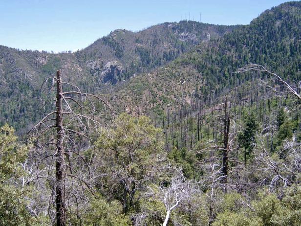
Photo Point 269, Catalinas, 7300 ft, June 2009. The view from Butterfly Peak, ESE to Mt. Bigelow. The upper extent of the Bullock Fire, shown by surviving confers on the upper right, corresponds closely to the boundary between the lower pine-oak ecological unit and the higher mixed conifer EU.
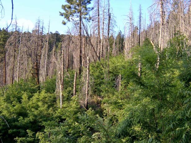
Photo Point 267, Catalinas, along the Butterfly trail, a north-facing slope about ¼ mile SE of Butterfly Peak, 6850 ft, June 2009. Locust, averaging 3.5 m tall, with 25-39% cover, are abundant along a 2003 burned area of the Butterfly Trail, near Novio Spring. Dead conifers were Douglas fir, Ponderosa, and SW white pine. Some Douglas fir survived the fire (15 m, 1-4% cover) along with Gambel’s oak (2.5 m; 1-4% cover — but with a few very large survivors, 12 m tall). Box elder is resprouting from stumps, and has already reached a mean height of 4.5 m, with 1-4% cover. Bracken fern gives another 5-9% cover.
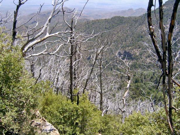
Photo Point 268, Catalinas, the view east from the burned SE-facing slope of Butterfly Peak, 7300 ft, June 2009. Both the foregound and the background slope are part of this EU. The foreground slope is dominated by a mix of silverleaf and netleaf oak, each about 2.5 m tall, and giving 10-14% cover. Schott’s yucca (0.8 m, 1-4%) and Ceanothus (0.8 m, 1-4%) are common associates. Bullgrass (0.7 m, 5-9%) thrived in openings.
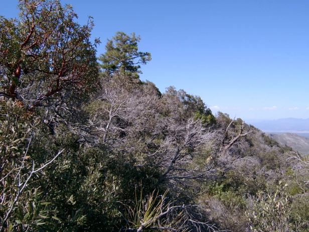
Photo Point 75, Catalinas, the view north from the Brush Corral trail, 6800 ft, September 2008. The redbarked tree at the left is a madrone, pretty but rare at this site. Silverleaf oak is the easy dominant, with 40-59%. Unburned oaks were 7 m tall; resprouted trees average 2 m. Chihuahuan pine (12 m, 5-9%) cover, although uncommon in this view, are typically common nearby. Beargrass, manzanita, and bush muhly grass each add another 1-4%.
Desired Conditions
Desired conditions are adapted from Ponderosa pine-evergreen shrub, mid-scale desired condition statements in March 2010 Coronado National Forest planning documents.
At the mid-scale, the ponderosa pine-evergreen shrub is characterized by variation in the size and number of tree groups depending on elevation, soil type, aspect, and site productivity. The more biologically productive sites contain more trees per group and more groups per area. Tree density within forested areas generally ranges from 20 to 80 square foot basal area per acre. Openings typically range from 10 percent in the more productive sites to 70 percent in the less productive sites. The mosaic of tree groups comprises a mix of even-aged and uneven-aged patches with all age classes and structural stages present. The mix of natural disturbances sustains the overall age and structural distribution.
Fires are of low- to mixed-severity, burning on the forest floor as well as in the overstory. Crown fires occur in small patches.
Forest structure in the wildland urban interface (WUI) has smaller, more widely spaced groups of trees than in the non-WUI. There are no stand-replacement fires in the WUI. As ignitions occur, flame lengths will typically be less than four feet. Forest stands are able to withstand and recover from periodic naturally occurring or unwanted, human-initiated wildland fires. Forest conditions in goshawk post-fledging family areas (PFAs) are similar to general forest conditions except that these forests contain 10 to 20 percent higher basal area in the mid-age to old tree groups than goshawk foraging areas and the remainder of the forest. Goshawk nest areas have forest conditions that are multi-aged but are dominated by large trees with relatively dense canopies.
Historic Mean Fire Return Interval (Schussman et al. 2006 literature review)
2-17 years for ponderosa pine
Primary treatment options (estimated representative project size range):
- Wildland fire: Prescribed fire and/or wildfire to maintain openings, reduce ground fuels, and site prep (1,000 to 30,000 acres per project)
- Fuelwood sales (targeting ‘invasive’ tree species to protect high value trees) to reduce fuel loading (up to 300 acres per project)
- Thinning around developments for safety-related fuel reduction (up to 500 acres per project)
Secondary treatment options (estimated representative project size range):
- First-entry mechanical treatments to prepare for fire reintroduction (mastication/crushing, pushing, thinning) (up to 2,500 acres per project)
- Herbicide and mechanical treatment for exotics (to maintain openings) (up to 1,000 acres per project)
- Grazing to reduce fuel loading
- Fuel break construction to aid in fire management
Other vegetation classifications:
Ecological System as defined by the Southwest Regional Gap Analysis Project
Biome after Brown, Lowe and Pase (1979)
Mid-scale Dominance Type (USFS Coronado NF GIS)
Community after Whittaker and Niering (1975)