Madrean oak/conifer/manzanita on hills and mountains with extensive rock outcrops
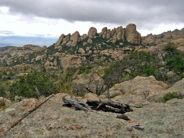
The Rockpile, September 2008, Rincon Mountain Wilderness, Coronado NF, looking northeast from the Italian Springs Trail at 5900 feet. Manzanita, pinyon, and silverleaf oak are co-dominants. This area burned during the 2003 Helen Fire.
Enormous outcrops of granite or gneiss define this EU. The rock might form cliffs like Pusch Ridge or Rincon Peak, or they might be knobs and domes as in the Wilderness of Rocks or the Rockpile on the northeast slope of the Rincons. The majority of this EU is NPS or NF wilderness. Hollin Basin, Reef of Rock, Barnum Rock, and the Little Rincons, are not wilderness, but still roadless. Windy Point is the only ELT (123e) within the EU that is accessible by vehicle.
Vegetation within this large EU is primarily pinyon, manzanita, and a variety of Madrean oaks — silverleaf, netleaf (Q. reticulata), white (Q. arizonica), and blue. Grasses are sparse, and usually no more than a scatter of deergrass (M. emersleyi). Within this EU the shrub live oak, Q. turbinella, is typically not a dominant or co-dominant species. However, the vegetation is often so dense (over 80% cover) between rock outcrops that its structure, or phsyiognamy, is recognized as “chaparral.” But with pinyon pine instead of shrub live oak as a dominant or co-dominant, it technically isn’t the ‘Arizona chaparral’ of Brown (1982) or the ‘Mogollon chaparral’ of the SW Gap project. Pinyon pine is not, like the shrub live oak, fire-adapted. Pinyons do not resprout, nor do the cones require fire to open.
Elevation within the EU ranges from 3300 to 8800 ft (1000-2700 m). At any elevation the abundance of rock amplifies the runoff, and often supports vegetation typical of a higher elevation. For example, even at this EU’s lowest elevations, along the foot of Pusch Ridge, there are blue oak and rosewood where there might otherwise be mesquite or palo verde. At higher elevations, such as the Wilderness of Rocks (ELT 154a), there are open parks of Ponderosa pine and, along the perennial stretches of Lemmon and Sabino creeks, cool basins with pine, Douglas fir and streamside galleys of alder and bigtooth maple. Another high elevation example is the Rincon Peak ELT (204a), characterized by silverleaf and netleaf oak, pine, and manzanita, yet also supporting a broad swath of mixed conifer and aspen on favorable north slopes.
At mid-elevations, this EU borders riparian zones that hold relic populations of Arizona cypress, e.g., Windy Point/Bear Canyon.
Aspect and slope vary dramatically throughout this EU, with dramatically different responses to fire. In the Catalinas, for example, Hollin Basin (ELT 124g) and Windy Point (123e) are both dominated by pinyon pine and manzanita. Yet Hollin Basin largely escaped the Aspen fire, while Windy Point burned, with its steep dry slopes (60% of the ELT) apparently carrying the fire over rock barriers. At other places and times, such as the Rockpile during the Rincon’s Helen Fire, or the Wilderness of Rocks during the Catalina’s Aspen Fire, fire creates a patchwork of victims and survivors, with islands of vegetation escaping the burn.
(Geology note: The rocky area near the Catalina’s San Pedro Vista is currently recognized as an extrusive outcrop of rhyodacite, not the more typical granite and gneiss. The change, however, is not apparent in the vegetation, which is typical of others at this elevation within the EU.)
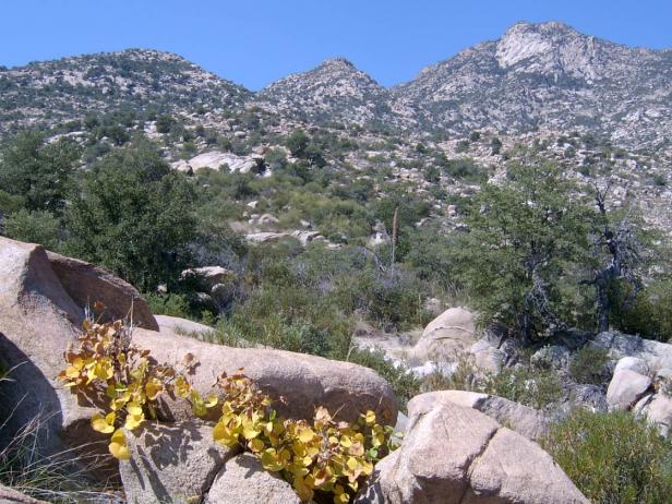
The Rincons, Happy Valley Lookout Peak, background right, as seen from Miller Ranch Trail near the NPS/Coronado NF boundary in October 2008, at 4700 feet. Three species of oaks, manzanita, and pinyon are the dominant plants. The yellow leaves of coral bean are in the foreground. All of the landscape pictured here is included within this ‘rocky’ EU.
Desired Conditions
Desired conditions are adapted from Madrean pine-oak woodland, mid-scale in March 2010 Coronado National Forest planning documents.
The size and number of patches of dense trees varies with disturbance, elevation, soil type, aspect, and site productivity. Patch sizes vary but are mostly in tens of acres. Grasses, forbs, shrubs, needle cast, and small trees provide fuel for the natural fire regime with a greater proportion of the ground cover as grasses and forbs as opposed to needle cast.
Vegetation structure in the wildland urban interface (WUI) will have a broad mix of different landscapes, such as open areas and scattered groups or clumps of woodland tree species.
Historic Mean Fire Return Interval (Schussman et al. 2006 literature review)
3-8 years for Madrean pine oak woodland
Primary treatment options (estimated representative project size range):
- Wildland Fire: Prescribed fire and/or wildfire to maintain openings, reduce ground fuels, and site prep (1,000 to 30,000 acres per project)
- Fuelwood sales only outside wilderness boundary (smaller diameter, including aspens) to reduce fuel loading (up to 300 acres per project)
- Thinning around developments, for fuel breaks elsewhere (up to 500 acres per project)
Secondary treatment option and justification (estimated representative project size range):
- Herbicide and mechanical treatment for exotics (Lehmann lovegrass, cheatgrass) and shrub management (to maintain openings) (up to 1,000 acres per project)
- Mastication/crushing to reduce ladder and ground fuels (up to 2,500 acres per project)
Other vegetation classifications:
Ecological System as defined by the Southwest Regional Gap Analysis Project
Madrean Pine-Oak Forest and Woodland
Madrean Pinyon-Juniper Woodland
Madrean Encinal
Mogollon Chaparral
Biome after Brown, Lowe and Pase (1979)
123.31 Encinal (Oak) Series
133.3 Interior Chaparral
Mid-scale Dominance Type (USFS Coronado NF GIS)
Oak, juniper, pinyon mix
Upper evergreen forest tree mix
Ponderosa pine
Community after Whittaker and Niering (1975)
Pygmy conifer-oak scrub